Fundy Footpath – Day 3

Looking to go on an adventure?  Get the gear first!

Visit my gear page here for questions about gear.

1313902.large

Goose Creek Campsite to Goose River – 7.4 km (4.6 miles)

*NOTE*  An additional 7.9 km (4.9 miles) is required to actually FINISH the trail and get to civilization.  This is the “mandatory approach trail”.  The hike from Goose River to find the approach trail is NOT explained well in the guide, and I recommend reading the bottom for help with navigation. 

Total Day 3 – 15.3 km (9.5 miles)

Total hiked after completion – 49.3 km (30.6 miles) TOTAL.

We made the 9.5 miles by 1 pm, crushing the day, because.. HUNGER!!!  All we could think of was, oh man – the car is right there!  9 miles away.  We can potentially get there at noon and immediately drive to eat the most food ever.  Warm showers were also on the mind.  But first, food.

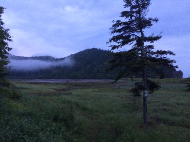
We had a tough decision to make.  Low tide was scheduled for 6:51 am, we had 2 crossings to make that were 7.4 km apart, with a 4 hour window to make both.  Knowing our previous days hiking rate, and our current exhaustion level, it wasn’t looking good.  However, we had hunger on our side.  I was not about to wait until 5 pm to cross Goose River.  We were up at 5 am, and out of camp by just before 6 am.
img_7220

Crossing Goose Creek sucks.  Neither of us had water shoes, because, who has time for those.  They are too heavy for camp shoes, and I have never really needed them.  I’ve made all my river crossings to date in my boots.  THIS crossing, however, was not sandal friendly.  I immediately lost my first sandal hiking the .5 km up river to the crossing.  The mud came up to our knees.  I didn’t even bother looking for it, I was too tired.  The mosquitos were on us, the rain had started, I was barefoot, and it was only 6 am.


We made it to the crossing, a slow trickle of shallow water.  The rocks were cutting into my feet, I was ready to put on some shoes and get my hike on!  The crossing took about 20 minutes for the minimal distance, which was a little disappointing.

On the other side, however, we went beast mode.  I carry mio energy whenever I hike, which came in handy.  The hike from Goose Creek to Goose River is super easy, comparatively.

We hiked up and over to Azore Beach, it was raining, but it was still a pretty site.

We got a little worried that we weren’t going to be able to make the crossing, until we came upon 2 hikers that had just crossed it, and said the water was still below their knees.  We ran from there.  We found the river!   We found the 0 km!  It was 3 hours past low tide and the crossing was super easy.  Rock hopping.  Never got wet.  What was all this about in the book then?

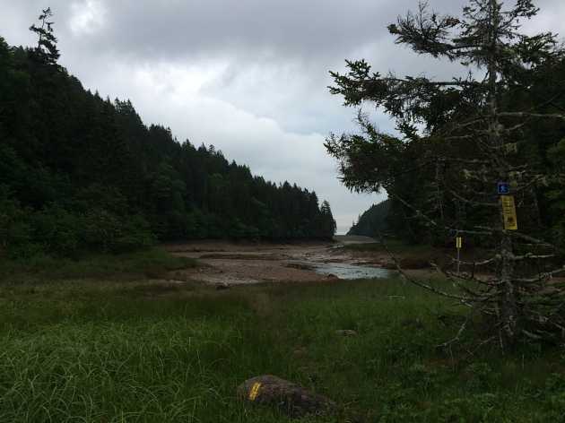
  • NOTE – Well, that’s when things got tricky.  We had to find the approach trail.  We saw some yellow blazes, assumed we were going the right way and walked for a couple hundred yards until it just ended.  We ended up in deep ocean channel, that was just void of water.  There was water in the center, with sloping hills on either side filled with mud, and a high tide water mark well above our heads 20-30 feet on either sides of us.  We realized it was 3 hours past low tide, with the safe crossing gone 1 hour ago, and started to get worried.  With no more blazes visible, panick set in a little bit.
img_7226

This is pretty much the end of the blazes.  Up ahead, it diverges left and straight.  There are footprints and paths going both ways.  The correct sequence from here is to hike straight, try to keep out of the mud, and once you get to the divergence, go straight across, up the hill, and on top of that hill you will see a log bench and some rocks.  Look very carefully and you will find a poorly marked entrance to the beginning of the approach trail.  The ONLY reason we found this, was because we saw a person.  We had walked around for a good 10 minutes in the wrong direction, and then turned around to try to find our bearings again.  This is not good to do when high tide is looming.  Hope that helps!

This section is beautiful!!!  And only 7.9 km from our car!!!  Did I mention I was hungry?  What did hot food taste like?  Is there lobster in New Brunsick?  How fast can an injured person run 5 miles with a 40 lb pack?  These are all questions in my mind as I surveyed the awesome scenery.

After taking 30 minutes to find the actual damn trail, we started on it.  IT WAS A ROAD!  We hiked the 5 miles in a little under 2 hours.

The End.  Aaaaand ready for the next one.
 

Lost Coast Trail – July 18 2015

The Lost Coast photoIt’s a new summer and time for a new adventure!  The plan is to hike the entire Lost Coast Trail in northern California.  This section includes both the beautiful Mendocino and Humboldt counties.  From my understanding, the Pacific Coast Highway (US 1) travels the entire length of the West Coast.  However, when developers encountered the King Range they decided the land far too unstable to develop a highway.  This resulted in 80 or so miles of untouched and almost inaccessible coastline in Northern California.  The nearest highway (101) is about 35 miles from the coast.  The result, one of the most remote wilderness areas in the state, and I am going to hike it!

photo-copy-2

Hiking, relaxing, going to bed, and waking up on the beach every day for about a week!  I’m so excited.  If you guys have followed any blogs of 2014 Appalachian Thru Hikers, there are a couple coming with me.  Gandalf, Goat, Roc Doc, and Kamikaze are all fellow thru hikers last year, and are coming with me on this journey.

197867Once again, I invite you to join me on this adventure.  I will create a daily blog, and publish once I have service.  (There is almost no service in the area).  There will be TONS of pictures, and I will have one more blog up about preparation before I go.  Preparation includes getting a map of the area, bear canister, shuttle info, etc.  This will be helpful if any of you are planning a hike of the Lost Coast Trail in the future!

d34db711d2e8e65cd00533f9d6f47e36Departure date is set for July 18.  I will be driving to San Diego, and up the Cali Coast, hitting LA and SF on the way, and camping with Gandalf, Goat, Roc Doc, and Kamikaze on the 17th, the shuttle taking us to our remote location on the 18th.

Afterwards, the plan is to go up to the Del Norte Redwoods, and take our time driving the entire Pacific Coast Highway on the way back to San Diego.  I look forward to the trip, and sharing it with you!

Magic

-Stretch

Day 128 – NH

Ethan Pond shelter to Lake of the Clouds Hut – 14.2 miles
1851.2 / 334.1

I am currently about to sleep on the floor of the ‘dining room’ that I call a living room at lake of the clouds hut. It is 10 pm and quiet time and There are teeNagers all around us, playing monopoly and gossiping. This is going to be a long night. However, it’s freezing out, it rained all day, and there is a roof over our head! As through hikers, we get to do a work for stay (a stay at one of the guts is around $125) so we stay free. We also get to eat leftovers of dinner AND breakfast! So awesome! For the work we did the dishes and then we recoiled the catchers under the grill and then spent about an hour scrubbing the burner plates. Not bad.

As far as the hike, I was up around 6 am and realized it was still pouring out from the night before. I quickly slept in. I finally got up, put wet clothes and shoes on and me and Dinosaur left around 7:45 am. And it was still raining. We quickly hiked the 3 miles down to Crawford notch. But then spent over 2 hours climbing up Webster cliffs and Webster mountain. Or as I like to call it, Sudden Slippery Death trail. We were basically rock climbing with packs on in pouring rain, above treeline. So sketchy!

But the clouds kept flying by and giving us glimpses of beauty so between shivers I was happy. I eventually left dinosaur to hike fast and made or to Mizpah Hut around 1:30. I found Grasshopper zeroing there, and Thin mint was there! I haven’t seen him since March. We wanted to work for stay at Lake of the Clouds hut. to do so you want to show up between 4-6 pm or they send you away if you’re early, and you will more than likely have other thru hikers (your competition) take up the only 2-4 available spots if you’re late.

I hiked with Thin Mint the whole way to lake of the clouds. It finally stopped raining, and it was good to catch up with him. Almost the entire hike was above tree line after climbing Pierce. I got beautiful views and was once again super excited about this trip. These were the views that made me want to do this hike in the first place! I had climbed all these mountains with my dad as a kid and the memories came flooding back with each view.

20140717-214310-78190600.jpg

20140717-214310-78190250.jpg

20140717-214308-78188818.jpg

20140717-214309-78189201.jpg

20140717-214311-78191332.jpg

20140717-214310-78190963.jpg

20140717-214309-78189553.jpg

20140717-214309-78189897.jpg

Day 93 – NY

Greymoore Spiritual Center to RPH shelter – 18.8 miles
1424.9 / 760.4

20140610-185857-68337711.jpg
I slept MAYBE 4 hours last night, so exhaustion set in hard today. Haven’t been sleeping well for a couple days now. We got up and out pretty early, around 7:45, with fully charged electronics. The church bells played songs for 5 minutes every hour until I fell asleep the first time.

We made pretty good timing for the first half of the day. The terrain has started to calm down a bit, no huge mountains to summit, no crazy ups or downs, but still a lot of ups and downs. It was about 75 today and cloudy, super humid though. It was misting and or feeling like it was about to rain all day. That, and the fact the ground was wet from last night, made it all kinds of buggy. I lost count after killing 10 Mosquitos, all of which bit me, and didn’t count the ones that got away. Seriously getting LIT UP out here.

We had lunch near a stream, for like 30 minutes til we couldn’t take the bugs anymore and set off. There was a cafe that we later found wasn’t open that we wanted to get to. It was at a beautiful lake, Canopus Lake beach.

20140610-185750-68270452.jpg
We got to the lake and unlike every water source in NJ and NY, it actually smelled like a decent lake! I don’t know why this excited me, but it did. Maybe signified I was getting close to NH/ME. Well the cafe was not open, and I was struggling to keep my eyes open. So I hooked up my phone in the restroom to charge, and fell asleep on a park bench.

Fresh was passed out in the grass near me and a guy in a tractor told us there was a campground up ahead. I politely declined and said I’m gonna stay here for another hour before moving on, which seemed to annoy the man. Well he went away like I hoped and I rested again.

We hit the finale of today’s trail after the lake, a pretty steep uphill section to Shanendoah mountain, which had a 911 memorial flag painted on top.

20140610-185436-68076879.jpg

The trail went 1000 ft down to our current shelter, which oddly enough, is in a neighborhood. I couldn’t imagine living on the same street as a hiker shelter haha. All that homeless looking hiker trash.. Well the good news is pizza delivers here, and I ate an entire one to myself. The caretaker showed up shortly after and hung out with us just shooting the breeze. I guess it would be cool to have a hiker shelter in your hood! Our mansion privy..

20140610-185709-68229382.jpg

Day 59

Fullhardt Knob Shelter to Bryant Ridge shelter – 27 miles
756.0 / 1429.3

Today was a big day, we were still excited about Mcafees Knob from yesterday and we decided to wake up early again and crush miles. Our original plan was to go 23, but halfway we ran into a girl chamomile who reminded us that it costs $20 to camp at Jennings Creek. Looks like were going 27! We made 13.5 miles by noon and we were exhausted, and had a big lunch. It was hot out! Hit around 81 degrees. Beautiful scenery and green trees though, important for the soul.

We had finished 23 miles when we decided to make a break for Jennings creek, it had a swimming hole. But when we got to the road we realized it had so much more. We got a hitch to it and they had almost a full menu of everything a hiker could ask for. Sodas, milkshakes, ice cream, bacon cheeseburgers, bacon, bacon, bacon. Bacon! Best part was, they had an arcade.. I ate a bacon cheeseburger, chicken nuggets, a chicken sandwich and 2 sodas and a pineapple juice. So good! She shuttled us back to the trail and here we are at the shelter, full and happy.

20140507-210701.jpg

20140507-210647.jpg

20140507-210631.jpg

20140507-210620.jpg

Day 51

Woods Hole Hostel to Holiday Motor Lodge – 10.4 miles
631.3 / 1554.0

Just to let everyone know, we are all surviving the storms here. Fresh had to tent in the pouring rain the other night so I met him in Pearisburg to chill at the motor lodge. I hiked just over 10 miles in non stop rain, with pretty gusty wind up on the Ridgeline. My plan was to keep going another 8, but after eating some food (a lot of Mexican food, so good!) I realized I was freezing and wet and Wednesday is also going to be another stormy day.

I had lunch with peppa and once again bid her adieu and found fresh. This motor lodge has a ‘bunk house’ for hikers, it’s awesome. We all chill in one big room, a computer a tv and hockey playoffs are on! We picked up about 78 beers for 7 of us and played beer pong, listened to music and watched hockey. I decided to take a zero tomorrow so I didn’t mind having some fun. Another great day on the ‘trail’!

20140430-114913.jpg

20140430-114921.jpg

20140430-114936.jpg

Day 23

Newfound Gap to the Pecks Corner shelter – 10.4 miles
217.2 / 1968.7

It’s beautiful out again! It must have been 60-70 degrees today. We got a free shuttle for the 15 mile drive from Gatlinburg to Newfound gap courtesy of NOC. We started up the 1000 ft incline and quickly found snow. The going was pretty easy, but started getting slushy. We passed some great views of the Smokeys (our first in days) and made it to the first shelter for lunch. I took a sun nap in the grass surrounded by snow which hit the spot.

We walked another mile and the trail started to become all ridges with cliffs to the sides, in the snow.. But the views! We found a place called Charlies Bunion that was so pretty we had to spend an hour there. They were giant knob rocks with straight drops on all sides. We took pictures videos etc. I will upload to youtube when I get service. Overall, the weather was perfect, a warm breeze, the sun shining, the sweet smell of the pines that surrounded us, and being up on the ridge lines made today one of my favorites!

On the other hand all the snow started to melt, the slush soaked my feet. If the trail wasn’t snow, it was slush, mud puddles, a giant river, or a stream. It was easy to get frustrated trying to walk in the slush, as your footing would give way after half a second and you would stumble every other step. The good always comes with the bad and today was overall amazing in it’s own unique way. I can’t wait to see the rest of the Smokeys!

20140401-200615.jpg

20140401-200606.jpg

20140401-200543.jpg

20140401-200533.jpg

Day 14

Wayah Bald Shelter to Wesser Bald shelter 10.6 Miles
131.4 / 2053.9

Woke up in the shelter to pouring rain. I was immediately glad I chose to sleep in a shelter. Slept in til 8:30 ish and started to get breakfast going. I lazily hung my food bag so it was easy to grab. We left around 10 and I had plastic grocery bags wrapped around my glove liners to make the perfect rain gloves.

The rain stopped around 11 and it was just misty and a little cold for the rest of the day. We decided to go 12 miles, stopping 5 miles at cold springs shelter for lunch. Some guy offered me a homemade version of a drug I wouldn’t want to try anyways, and then asked for my empty peanut butter jar which I gladly gave him and we were on our way.

We rested in telico gap where we met a family wig found out we’ve been hiking since march 10th and were pretty excited about that. 2 weeks in the woods! Kinda cool. We made it to our current shelter where we found reroute! She had once again skipped ahead, bringing our hotdogs we forgot at the budget inn!! Whaaaaaat?! So awesome. This is why I write a blog, so people know where to find me, and can bring hot dogs and or hard liquor. Just kidding. But a great way to end the day! It’s currently 32 and dropping so I got in my bag and am about to freeze for the night. Goodnight!

20140324-130215.jpg

20140324-130227.jpg

Day 8

Miles today – 0

Took a zero today. Annnnd it was amazing!! Started the day off with so much food at blueberry patch shelter. Pancakes, home made blueberry syrup, eggs, biscuits, hash browns, sausage, oj and coffee. And I was STARVING after the rainy muddy cold day yesterday. We decided to hitch a ride to town (hiawassee, ga) after breakfast to stay and let our sore joints rest. Mcdonalds, grocery store, thrift store, beer store, beers, Dairy Queen. NOM!

A well deserved day of gluttony. We should be in North Carolina by tomorrow night! Can’t wait!

Breakfast and a very wet tent from 2 days ago. (Still wet)

20140317-212639.jpg

20140317-212646.jpg

I’m (temporarily) retired

Last night was my last day of work, at least until September.  This was all pre-planned, I did not quit in the way we all dream of quitting our jobs, but worked hard until the last couple minutes, and bounced quietly.  But I’m done!  This is a gift for myself for my 30th birthday.  I have been aimlessly meandering through life for the last 29 years, pursuing different goals, career paths, girlfriends etc.  I feel I have lacked what I love, and that is adventure.  It’s easy to lose sight of what drives you, with the thousands of daily tasks, and everything aligned and pointed to adventure.  I went with it.  I have until Tuesday to prepare for the road trip to MA.  I need to clean the entire house, make my room rentable (if my roomate needs to rent out a room, she claims the entire house while I’m gone), and get my gear in order. 

Tomorrow I will be hiking Picacho Peak Image which is easily the sketchiest, (most fun) mountain in town.  Saturday night, we will be heading up to Flagstaff to celebrate my 30th birthday, and a little bit of a going away party, since I won’t be seeing them again for 6 months(ish).  Sunday is my designated hangover day, Monday is designated for packing my car up, and Tuesday I must wake at the crack of dawn, take my dog hiking, and then head out for a nice 14 hour drive to Denver.  I will be staying with my college friend Rachel for the night, maybe two nights, and then I have until March 9th to get to MA.  So who knows! 

Until then, I will just be enjoying the weather of Arizona (80’s until I leave).

“And if you ever get lost, you can just follow your dreams”