Hiking the Fundy Footpath

Before you start planning, make a gear list!  I have mine accessible at this link.  This is the gear list I had for the Appalachian Thru-hike I completed, and my gear does not deviate much from it.  I would not bring the cold weather gear, as it is not applicable on the Fundy Coast.

Gear page

01_ATgear_olivier_750x400

Hiking the Fundy Footpath is beautiful, remote, challenging, and inspiring.  But above all else, it’s an adventure!  I did a ton of research before setting out on this one, and I have written most of my findings.  The Getting prepared section has some brief information.

745_403_footpath_map_2009b

Maps can be purchased through this link – http://www.fundytrailparkway.com/en/the_fundy_footpath/ 

*Hint (Literally call them and request one, contact information under “contact us”).  If you are feeling ambitious, you may also ask them about taxis, I have a couple listed under Day 1.

Getting prepared

Day 1 has all the information about where we got our maps, who we picked to take for our taxi and a way to reach them, where to park etc.  People usually leave their car at Point Wolfe Campground which is 8 km from the start (or end) of the trail.  We left our car there and taxid to the other terminus (Big Salmon River).

Day 1 – Big Salmon River to Little Salmon River 17.9 km (11.12 miles)

p1040098

After realizing this hike was a little more challenging than originally anticipated, which is fine for me, I had a minor melt down on day 2.  We hiked only 10 miles, but that literally took 10 hours.  I haven’t hiked that slow in God knows how long, but what a day!  There are shots of the trail and images of the map in day 2.

Day 2 – Little Salmon River to Goose Creek campsite – 16.1 km of hell (10 miles)

Day 3 we were pretty much wiped, and finished the trail by 10 am.  2 days and 4 hours.  Not bad!  But the real reason we hurried on day 3 was hunger and the thought of hot food and all those lobster rolls all around the area.  New Brunswick has some AMAZING seafood.

This section also has some information and pictures regarding finding the end of the trail, as you cross Goose River, crossing over into the approach trail.  They don’t exactly interconnect immediately, and you may want to read about it before hand.  The map wasn’t exactly informative.

Day 3 – Goose Creek Campsite to Goose River (ending) to Point Wolfe Parking Lot – 15.3 km (9.5 miles)

Afterwards, we opted out of the immediate hot showers available at Point Wolfe Campground, and instead traveled to Alma 5 minutes away.  Alma is a quiet little touristy town chalk full of seafood. Here is some info on Alma, although I found asking locals was the best way to get what I wanted.

http://www.tourismnewbrunswick.ca/Products/V/Village-of-Alma.aspx

Fundy Footpath – Day 3

Looking to go on an adventure?  Get the gear first!

Visit my gear page here for questions about gear.

1313902.large

Goose Creek Campsite to Goose River – 7.4 km (4.6 miles)

*NOTE*  An additional 7.9 km (4.9 miles) is required to actually FINISH the trail and get to civilization.  This is the “mandatory approach trail”.  The hike from Goose River to find the approach trail is NOT explained well in the guide, and I recommend reading the bottom for help with navigation. 

Total Day 3 – 15.3 km (9.5 miles)

Total hiked after completion – 49.3 km (30.6 miles) TOTAL.

We made the 9.5 miles by 1 pm, crushing the day, because.. HUNGER!!!  All we could think of was, oh man – the car is right there!  9 miles away.  We can potentially get there at noon and immediately drive to eat the most food ever.  Warm showers were also on the mind.  But first, food.

We had a tough decision to make.  Low tide was scheduled for 6:51 am, we had 2 crossings to make that were 7.4 km apart, with a 4 hour window to make both.  Knowing our previous days hiking rate, and our current exhaustion level, it wasn’t looking good.  However, we had hunger on our side.  I was not about to wait until 5 pm to cross Goose River.  We were up at 5 am, and out of camp by just before 6 am.

img_7220

Crossing Goose Creek sucks.  Neither of us had water shoes, because, who has time for those.  They are too heavy for camp shoes, and I have never really needed them.  I’ve made all my river crossings to date in my boots.  THIS crossing, however, was not sandal friendly.  I immediately lost my first sandal hiking the .5 km up river to the crossing.  The mud came up to our knees.  I didn’t even bother looking for it, I was too tired.  The mosquitos were on us, the rain had started, I was barefoot, and it was only 6 am.


We made it to the crossing, a slow trickle of shallow water.  The rocks were cutting into my feet, I was ready to put on some shoes and get my hike on!  The crossing took about 20 minutes for the minimal distance, which was a little disappointing.

On the other side, however, we went beast mode.  I carry mio energy whenever I hike, which came in handy.  The hike from Goose Creek to Goose River is super easy, comparatively.

We hiked up and over to Azore Beach, it was raining, but it was still a pretty site.

We got a little worried that we weren’t going to be able to make the crossing, until we came upon 2 hikers that had just crossed it, and said the water was still below their knees.  We ran from there.  We found the river!   We found the 0 km!  It was 3 hours past low tide and the crossing was super easy.  Rock hopping.  Never got wet.  What was all this about in the book then?

  • NOTE – Well, that’s when things got tricky.  We had to find the approach trail.  We saw some yellow blazes, assumed we were going the right way and walked for a couple hundred yards until it just ended.  We ended up in deep ocean channel, that was just void of water.  There was water in the center, with sloping hills on either side filled with mud, and a high tide water mark well above our heads 20-30 feet on either sides of us.  We realized it was 3 hours past low tide, with the safe crossing gone 1 hour ago, and started to get worried.  With no more blazes visible, panick set in a little bit.

img_7226

This is pretty much the end of the blazes.  Up ahead, it diverges left and straight.  There are footprints and paths going both ways.  The correct sequence from here is to hike straight, try to keep out of the mud, and once you get to the divergence, go straight across, up the hill, and on top of that hill you will see a log bench and some rocks.  Look very carefully and you will find a poorly marked entrance to the beginning of the approach trail.  The ONLY reason we found this, was because we saw a person.  We had walked around for a good 10 minutes in the wrong direction, and then turned around to try to find our bearings again.  This is not good to do when high tide is looming.  Hope that helps!

This section is beautiful!!!  And only 7.9 km from our car!!!  Did I mention I was hungry?  What did hot food taste like?  Is there lobster in New Brunsick?  How fast can an injured person run 5 miles with a 40 lb pack?  These are all questions in my mind as I surveyed the awesome scenery.

After taking 30 minutes to find the actual damn trail, we started on it.  IT WAS A ROAD!  We hiked the 5 miles in a little under 2 hours.

The End.  Aaaaand ready for the next one.


Fundy Footpath – Day 2


Little Salmon River to Goose Creek Campsite – 16.1 km.  (10 miles)

Total 34 km (21.2 miles)

IMG_7203

Hell of a day!  We met some Canadian hikers doing the same trail last night, and camped with them.  They told us that today was the hardest section of all.  Today WAS the hardest day.  It was a serious roller coaster of steep, and I mean steep, uphills, marshes on top, steep descents to creeks, up and around inlets etc.  My knee had started aching the day before, so I was a little worried about it.  But hey, we made it.

Section 1 – Little Salmon River to Wolf Brook – 4.5 km (2.8 miles)

image1(1)

4.5 km.  2.8 miles.  For some reason, this took us roughly 3.5 hours!  This section was a rough way to start the day.  We woke up early, and got out of camp at 7 am, proudly packed up everything quick and thought we were going to make it to Azore Beach (we really wanted to stay there).  As you can see, the trail from Little Salmon River goes up an asskicker.  Being that it was only 7 am, we thought we’d beat the heat.  The humidity index went WAY up, and we found ourselves out of breath and taking off clothes near the top.  The top section was murky, swampy, something out of Vermont.   We made it to our first stop at Rapidy Brook, and we realized it took us almost 2 hours to hike the 2.5 km.  There is a really nice bridge here, and a great place to fill up water.

The trip to Wolf Brook was easier, except once again on top, there was a huge swamp.  We were both super tired but the silly talks about food and Canadian Panther Ticks made the journey a little more easy on the feet.

Wolf Brook to Telegraph Brook – 2.0 km – to Quiddy River 6.0 km (10.5 for the day – AND LUNCH!)

Every time we got down to a brook I got all excited!  We are making progress!  And I get to stop and take a long break.  By Telegraph Brook, I was beat!  Everything was hurting.  This was the extremely hard part, and I was in the middle of it.  We were both in shock at this point and sat down and took a good 20 minute break.  We ran into a couple of hikers hiking the other way, they gave us some info about the trail which wasn’t too positive, and had a nice little snack.  I started realizing this was going to be a long day!  Telegraph Brook is a pretty nice place to stop for a break, a nice pool of water.

IMG_7216

I’ll be honest, getting up and hiking after sitting down sucked.  Last thing I wanted to do.  We got to climb up and away from the ocean, back down to another brook, a steep up a mountain, and then drop a swift and very steep descent to Quiddy River.  I was in a lot of pain and in a sour mood by the time we arrived here, and we weren’t making the time I thought we would.  Quiddy River was a GREAT place to take the shoes and socks off and just relax and soak the feet.

Quiddy River to Goose Creek Campsite – 6 km (3.72 miles)  Total for the day – 16.1 km (10 miles).image1(2)

I realized we were going to get to Goose Creek at 6 pm, perfect time for a low tide crossing.  10 hours to hike 10 miles, I was not very happy with.  I felt like since it stayed light out until 10 pm, why not make it to Jim Brook or Rose Brook?  And the answer to that question, is because I zombie walked into Goose Creek, I don’t think I had enough energy to muster up my evening chores!  Getting water for instance.

After the section we just went through, this was not bad at all!  Yes, going up from Quiddy River sucked.  Just to come all the way back down to sea level again, just down the path a little bit.  In fact, I overheard the Canadians talking about walking down that section in their water shoes and skipping the uphill, because the road and ATV trails connect to the actual trail.  We should have waited for them!  The uphill was unrelentless.  The downhill part was awesome, about 2 km of easy downhill.  Unfortunately, this is when my girlfriend started getting the bad blisters.  We had duct taped her feet since her shoes weren’t really broken in when we started (rookie mistake 😉 ).  I have had great success with duct tape.  We were just really beaten down by this part, and we understood we were just going down the same hill we climbed up, only to be about .5 km away from where we started, while hiking about 3.

But those views though!

IMG_7217

The trail meandered along the beach for hours, it seemed to stretch out longer, I felt like this was all the maps fault.  We finally made it to Brandy Brook!   And then hiked the 1 km to our campsite.  Once we got there, 10 hours later, we realized… This is where we are sleeping tonight.  On the plus side, Goose Creek Campsites are dope looking!

The rest of the evening was quite calm if I remember correctly.  Same Canadian neighbors showed up, not many spots to sleep in, but we all fit.  Another bear box at this site.

Interested in your own camping experience?  Check out my lengthy gear page!

Fundy Footpath Day 1

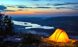
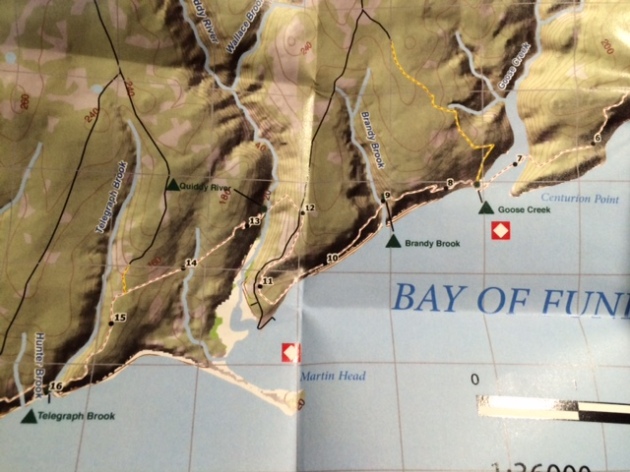
Point Wolfe campsite to Big Salmon River – 2 hour taxi ride.  Followed by hiking from Big Salmon River to Little Salmon River – 17.9 km.

Alexi showed up at whatever time I had asked of him, I even changed the time on him last minute as I forgot that there was another time difference when we crossed over to Canada into New Brunswick.  He brought coffee, he was friendly, he told us all about the sites, and even stopped and showed us his favorite spots while telling us the history.  He tried to stop at a restaurants for world famous seafood chowder before we departed but it was closed as we asked him to leave so early.  Put him in as one of your options.  You can contact Alexei Kalinin for more information at –

Alexei

Go Fundy Тours
(506) 898-1312

He happened to be our cheapest option, and the experience was great, so just wanted to put that out there for those who are interested in taxi options.  The plan was to hike back to our car at Point Wolfe Campground (yes you can park for free).

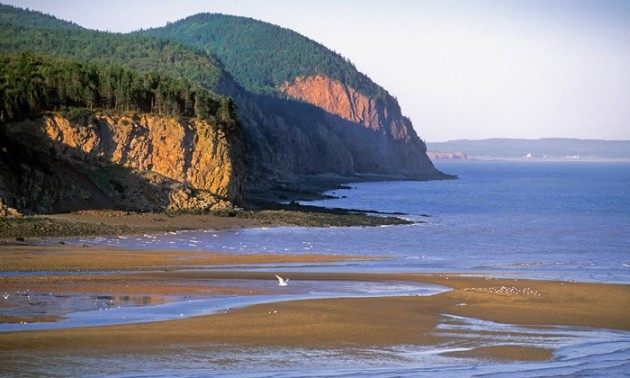
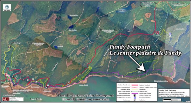
2 of Alexis favorite spots on the way to Big Salmon River (the Western Terminus)

Now, the hike – Day 1 – Big Salmon River to Little Salmon River

17.9 km (11.12 miles)

FYI, there is available water everywhere.  Do not worry yourself with packing too much, I carried just over 1.5 liters at each water location, and never ran out.

Big Salmon River is the Western Terminus of the Fundy Footpath, and has a visitor center complete with bathrooms and a shop in case you forgot anything.  They ask for your emergency contact information, estimated date of finishing and they WILL contact you if they do not hear back from you by the time you are done.  This turned out to be a dangerous trek, and we met a couple people who were rescued from this hike the year before.  Fun!  The most important info to take away, if you do call 911, you must tell them you are in New Brunswick, as all call GPS are rerouted to Nova Scotia, and they will spend all their time searching for you there.

We signed in and she told us quick directions how to get to the trail.  I was half listening, because I believed this trail to be blazed with white blazes, which I am familiar with following having hiked the Appalachian Trail.  The entire trail has a map and guide, available for purchase at both ends of the park, since mine never arrived after I sent for it I purchased a new one here.  It breaks up the trail into sections about 4-5 km long, and is pretty descriptive.  I will reference these points in my blog.

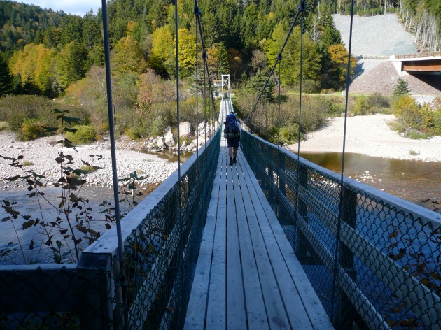
Leaving the visitor center, we crossed the bridge and took some pictures.  This was my girl friends first backpacking trip!  And she was entirely dependent on me to not get lost…

We got lost immediately after crossing the bridge!  The trail looks like this.

IMG_7165
Pretty much after walking on a nice path that is a trail, the trail disappears.  This will happen again and again and again, throughout the entire hike.  You must guess where to go next, and sometimes the guide is helpful.

After losing all credibility in front of my girlfriend, we followed the river staying on the eastern side, up to almost the mouth of it.  Guess what?  The trail starts there, and there were no markers pointing that way.  If you want to hike this trail, cross the bridge, pretend you know what you are doing and make your way towards the ocean on the east side, and BOOM – TRAIL.  I wish someone had told me that.  Thinking back, the lady at the visitor center probably did.  Moving on,

Big Salmon River to Long Beach Brook – 4.5 km (2.79 miles). 

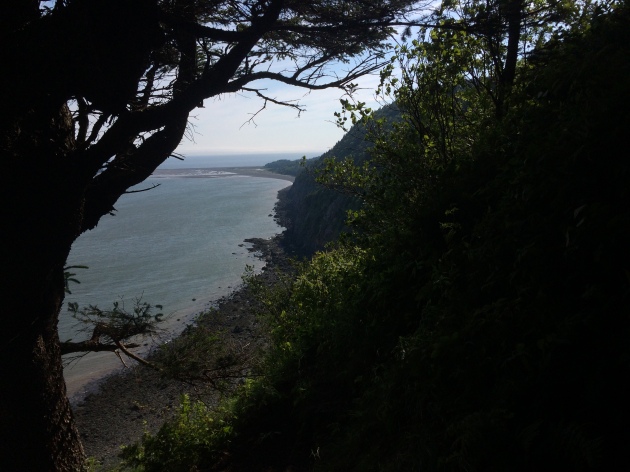
EASY!  Except we got lost again.  Guess what?  Those white blazes that are on the trees?  They say parts of the trail are washed out.  In Maritime Canada, that means 500 foot wide rock slides, tearing down all trees holding any blazes on them.  Where the f*ck did the trail go.  I don’t know.  You’ll find it, just look very carefully.  They have gone back and marked it, but holy hell, this trail is in bad shape. Not bad shape due to lack of maintenance, bad shape due to constant bombardment of way too much rain, slopes of 60-80 degrees, and apparently the earth caving in on itself.  I mean, look at this fun.


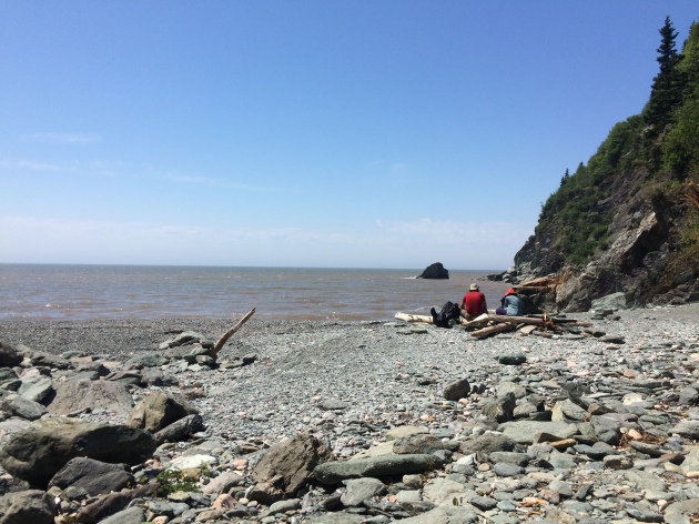
This was one of the easier sections however, and we were able to reach Long Beach Brook in about 1.5 hours.  There are bathrooms and benches to sit at and take a break right on the ocean.  This will be your last luxury of seeing a parking lot also.   We saw 4 hikers ahead of us just finishing their break, and we talked to some people hanging around the beach.  2 couples in their 60s that were actually rescued last year on the part we were just on.  Oh, and they told my girl friend there were bears… Jerks.  I had been lying to her up until that point.  We had a nice snack and moved on.

Long Beach to Seeley Beach 3.8 km (2.36 miles) 

Total – 8.3 km (5.15 miles)

After sitting for a while on the benches on the beach we took off.  But once again, where the EFF did the trail go???  There are no signs pointing to where the trail picked up again.  Luckily we saw the other hikers leaving the bench spots up on the pier by the parking lot.  We searched and searched, and finally we found what looked like a trail could be.  This was right next to the last bench by the ocean, a small unmarked trail leads around the corner and uphill.  There were no blazes, just pink ribbons signifying that maybe they are working on this section.  This turned out to be the trail (we did lots of back tracking to make sure).  Once we were on the trail, it was easy going again.  This section ended up being the easiest and quickest walk, we were quickly to Dragons Tooth before we knew it.  There were signs that there was blasting going on, but we made it around the dynamite, around the 500 ft rock slides that brought down every surrounding tree with it, and down to Seeley Beach.

Seeley Beach was rocky, windy, remote, a nice place to take a break.  The trail follows the beach here for about 1000 ft, before going back up into the woods.  We had lunch here.  This has one of those cross at low tide warnings.  We crossed a tiny section that was above our knees.

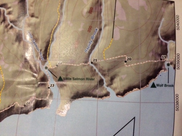
Seeley Beach to Cradle Brook – 4.6 km

Total to Cradle Brook – 12.9 km (8.01 miles)

From here, its stairs straight up.  The hike to Cradle Brook was tough, up to the top, marshes on top, down again, up again etc.  Usually I wouldn’t mind, but the trail was weathered as I said, steep, lots of opportunities to miss the trail etc.  We started resting every time we got to a brook, we were tired.  It was only 4 pm, and Little Salmon River was only 5 km more.

Cradle Brook to Little Salmon River – 5 km (3.1 miles)

Total – 17.9 km (11.12 miles)

We were wiped!  The trail got very steep up and over cradle brook to Little Salmon River.  This part sucked.  This 11 miles was harder than starting the Appalachian trail, more comparative to the whites, without the 4k elevation.  Just ups and downs, roots and rocks and roots and rocks.  We should probably have stopped at Cradle Brook, but it was only 4 pm(ish) and daylight literally stays until 10pm.  We’re not suckers!

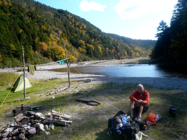
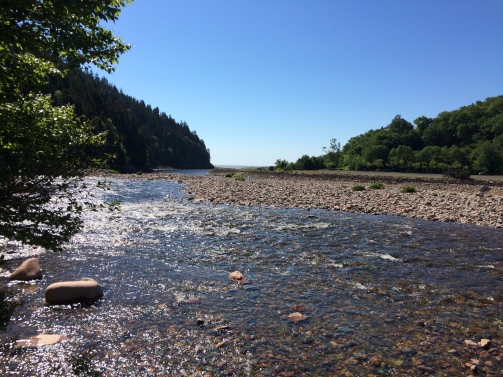
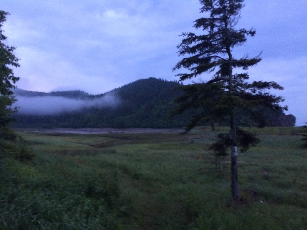
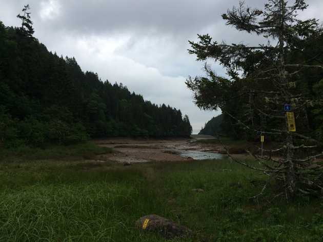
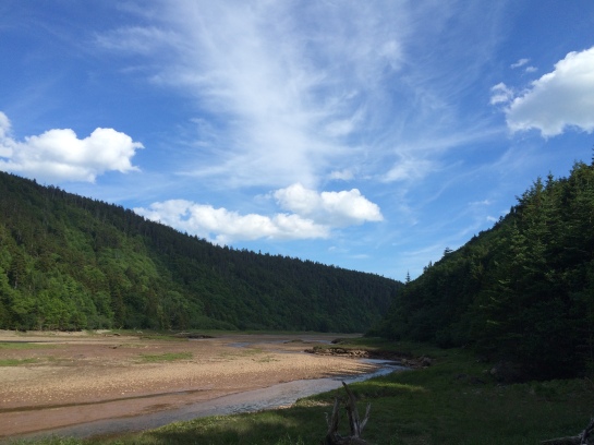
We hiked the 5 painful miles, and descended rapidly to Little Salmon River, where we just came out into a basin, at low tide, and said whaaaaaaat.  Apparently you take a sharp left, hike .3 – .5 km and cross the river.  There are a bunch of trails marked blue blazes (ATV trails), don’t be fooled.  The trail is hidden in a foresty inlet, a bunch of rocks leading into an enclosure that doesn’t look like a trail at all.  This is it.  Hike up just 100 ft, and you will see a beautiful campsite, with a bear box and a privy!!!  Whaaaaat.  I didn’t think I would see a privy on this trail.  The bear box added to my girl friends fears of bears, and the Canadian hikers we met shrugged it off.

We set up camp, ate our stupid hiker dinners, listened to Canadians talk about their lives, I eventually crawled out of my tent at 8 pm to join them at the fire, consuming half a bottle of my whiskey, while my girl friend straight up passed out hard.  The fire continued well past 10 pm, as the sun was still out (seriously?), and finally I got to sleep for about 5 hours.


Fundy Footpath – Prep and beginning day 1.

01_ATgear_olivier_750x400  Get your gear first!   Amazon Outdoor Gear

The Fundy Footpath.  The largest tidal zone in the world.  A continuation of the Appalachian Trail (international Appalachian Trail).  Ocean.  All reasons I chose this hike this summer.  Also, the hike was only 30 miles, and I would be taking my girl friend on her VERY FIRST backpacking trip.  In retrospect, this was not the best hike for a first timer…  It is extremely difficult :).  She’s still with me though!

I was able to find lots of information about this hike, including various blogs and youtube videos.  Understandably, most blogs and videos complained about how rugged and tough the trail was.  Being the over-confident hiker I am, I laughed at most of what was written and wrote it off.  (I’ve hiked the 49.3 km or 3o miles in just a day before with a full pack).  I shit you not, it took me 10 hours to hike 1o miles on this trail.  I realized on day 2, they weren’t joking!  This is an intense hike.  Compared to the Appalachian trail, where you will climb a mountain, get a spectacular view, climb back down, repeat.  This was climb 1000 vertical feet in less than 1 mile, no view, immediately descend, repeat.  Getting past that part, its beautiful, remote, rugged, and most of the trail is completely destroyed by the coastal rains.  Be prepared to hang on to a lot of roots as you try to space your feet perfectly on the 6 inches of what remain of the trail.

SO, that being said, let’s get to it!  Preparing for the hike.  The hike ends (or begins) at point wolfe campground.  We decided to camp there, and get a taxi to the other end, the suspension bridge at big salmon river.  I called various sites and Alexi offered to take us for 150 Canadian.  The people at the information center were charging about 250.  If you are feeling adventurous, and lucky, we ran into a couple from Quebec that parked their car, and then waited to meet someone heading the opposite direction, giving them their car keys, and asking them to park their car for them at the opposite side!  Dang guys!  Canadians sure are polite!

The drive from Pointe Wolfe campground to big salmon river is about 2 hours.  We got there around 10 am, signed in the register and started our journey.  We quickly got lost immediately after passing the suspension bridge.  Which I will get to in my next post.  Did anyone mention it was really easy to get lost on this hike???


Looking towards Canada for the next trip

1313902.large Camping and the Outdoors

East Coast of Canada!  Who’s coming with me?!

5985226459_f24c6e1af3

This looks like the East Coast version of the Lost Coast Trail I hiked last summer.

Fundy-c-J-Pleau-Parcs-Canada-700x420

I have been doing some research on great trails off the East Coast, the farther north the better, and I stumbled across “The Fundy Footpath“.  It is one of the biggest tidal zones in the world, as the Atlantic Ocean sweeps into this channel called the Bay of Fundy.  The tide rises upwards of over 100 feet, and back down!  Insane.  Plus, it’s beautiful!

A new place, on the ocean, insanely beautiful, a new country, a new adventure.

fundy.jpg

If anyone has any 1st person experience with this

area, feel free to reach out!  Looks like we’ll be heading out around early July.  Now, who’s coming with me?

Looking for gear reviews?  Check out my gear page for my completed Appalachian Trail Thru hike.

-Stretch


Next upcoming adventure – Joshua Tree for New Years

1313902.large Camping and the Outdoors

My girl friend and I have decided to venture away from the crowded bars and streets of the cities, and into the wilderness of Joshua Tree, which (by the way) has some of the BEST stargazing in the world.  Just take a gander.MilkyWayParkEntrance_LLaw_688x400The-Milky-Way-Stargazing-in-California-Joshua-Tree-national-Park

We are excited to explore the hikes and the rocks and look at the stars.  We will, of course, be sharing our experience through this blog.  The nights WILL be cold so it is important to bring the right gear.

I bought (for my road trips and sharing with my gf and her 6 year old) a Marmot Unisex Tungsten 4p Tent.  I’ve used it to camp the entire Pacific Coast Highway and various other adventures in Sedona etc.  This tent has TONS of room, I can literally stand up in it.  The rain fly that comes down, has a ton of capacity for items to place under the vestibule to prevent from getting wet, and it can keep you warm.  I think it could comfortably sleep 4 full adults, maybe even 5!

I have a very warm sleeping bag from Western Mountaineering sleeping bags.  They have the best quality for warmth, they are expensive, but worth it.  If you are planning on camping somewhere freezing, it will be worth your while.

We are also planning on bringing tons of food with us.  A cooler full of items to cook and what not!  I know they have tons of stoves out there for backpacking, but what I never had was a car camping stove.  It’s a totally new idea to me!  So I went out and did some research and found an awesome one that has been working well.  Coleman Triton Series 2 burner works great, and its pretty cheap comparatively.  We cooked quesadillas and pancakes and eggs mostly, but you can use it for anything.  Better believe I’m bringing this with me!  Including my kitchen I’ve purchased mostly from the dollar store.  This is where you can completely skimp.  Plates, cups, forks, shredders, cutting boards etc, can all be bought at the dollar store.

One last purchase was a 5 gallon water container to have some water to last us days.  Its a pain to get water every morning and night when camping so its good to tow around.  Coleman water jug (5 gallon)Pretty cheap!  We will see how it works coming up!

Can’t wait to ring in the new year in a beautiful setting, with fires and stargazing!  I am excited to share it with you all.  Set the date, we set off December 29.

Oh, and I can’t forget my glow in the dark frisbee 😉


Joshua Tree, here we come!


1313902.large Camping and the Outdoors