Fundy Footpath – Day 3

Looking to go on an adventure?  Get the gear first!

Visit my gear page here for questions about gear.

1313902.large

Goose Creek Campsite to Goose River – 7.4 km (4.6 miles)

*NOTE*  An additional 7.9 km (4.9 miles) is required to actually FINISH the trail and get to civilization.  This is the “mandatory approach trail”.  The hike from Goose River to find the approach trail is NOT explained well in the guide, and I recommend reading the bottom for help with navigation. 

Total Day 3 – 15.3 km (9.5 miles)

Total hiked after completion – 49.3 km (30.6 miles) TOTAL.

We made the 9.5 miles by 1 pm, crushing the day, because.. HUNGER!!!  All we could think of was, oh man – the car is right there!  9 miles away.  We can potentially get there at noon and immediately drive to eat the most food ever.  Warm showers were also on the mind.  But first, food.

We had a tough decision to make.  Low tide was scheduled for 6:51 am, we had 2 crossings to make that were 7.4 km apart, with a 4 hour window to make both.  Knowing our previous days hiking rate, and our current exhaustion level, it wasn’t looking good.  However, we had hunger on our side.  I was not about to wait until 5 pm to cross Goose River.  We were up at 5 am, and out of camp by just before 6 am.
img_7220

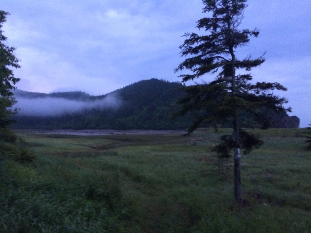
Crossing Goose Creek sucks.  Neither of us had water shoes, because, who has time for those.  They are too heavy for camp shoes, and I have never really needed them.  I’ve made all my river crossings to date in my boots.  THIS crossing, however, was not sandal friendly.  I immediately lost my first sandal hiking the .5 km up river to the crossing.  The mud came up to our knees.  I didn’t even bother looking for it, I was too tired.  The mosquitos were on us, the rain had started, I was barefoot, and it was only 6 am.


We made it to the crossing, a slow trickle of shallow water.  The rocks were cutting into my feet, I was ready to put on some shoes and get my hike on!  The crossing took about 20 minutes for the minimal distance, which was a little disappointing.

On the other side, however, we went beast mode.  I carry mio energy whenever I hike, which came in handy.  The hike from Goose Creek to Goose River is super easy, comparatively.

We hiked up and over to Azore Beach, it was raining, but it was still a pretty site.

We got a little worried that we weren’t going to be able to make the crossing, until we came upon 2 hikers that had just crossed it, and said the water was still below their knees.  We ran from there.  We found the river!   We found the 0 km!  It was 3 hours past low tide and the crossing was super easy.  Rock hopping.  Never got wet.  What was all this about in the book then?

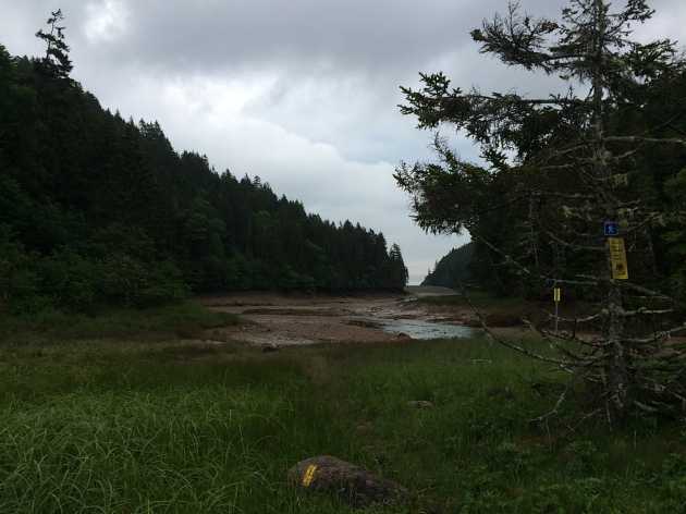
  • NOTE – Well, that’s when things got tricky.  We had to find the approach trail.  We saw some yellow blazes, assumed we were going the right way and walked for a couple hundred yards until it just ended.  We ended up in deep ocean channel, that was just void of water.  There was water in the center, with sloping hills on either side filled with mud, and a high tide water mark well above our heads 20-30 feet on either sides of us.  We realized it was 3 hours past low tide, with the safe crossing gone 1 hour ago, and started to get worried.  With no more blazes visible, panick set in a little bit.
img_7226

This is pretty much the end of the blazes.  Up ahead, it diverges left and straight.  There are footprints and paths going both ways.  The correct sequence from here is to hike straight, try to keep out of the mud, and once you get to the divergence, go straight across, up the hill, and on top of that hill you will see a log bench and some rocks.  Look very carefully and you will find a poorly marked entrance to the beginning of the approach trail.  The ONLY reason we found this, was because we saw a person.  We had walked around for a good 10 minutes in the wrong direction, and then turned around to try to find our bearings again.  This is not good to do when high tide is looming.  Hope that helps!

This section is beautiful!!!  And only 7.9 km from our car!!!  Did I mention I was hungry?  What did hot food taste like?  Is there lobster in New Brunsick?  How fast can an injured person run 5 miles with a 40 lb pack?  These are all questions in my mind as I surveyed the awesome scenery.

After taking 30 minutes to find the actual damn trail, we started on it.  IT WAS A ROAD!  We hiked the 5 miles in a little under 2 hours.

The End.  Aaaaand ready for the next one.
 

Road Trip – Part 2 – Grand Forks, ND to Olympia Beach Park – Washington

IMG_4094 IMG_4100 IMG_4101 IMG_4104 IMG_4113 IMG_4119 IMG_4127 IMG_4140 IMG_4142 IMG_4145 IMG_4146 IMG_4156 IMG_4158 IMG_4166 IMG_4175 IMG_4186 IMG_4188 IMG_4193 IMG_4201 IMG_4204 IMG_4205 IMG_4210 IMG_4211 IMG_4216 IMG_4222 IMG_4226 IMG_4227 IMG_4228 IMG_4230 IMG_4232 IMG_4233

2 Month countdown!

Wow, everything has been flying by.  With Thanksgiving, Christmas, New Year, work and the amount of other crap I keep myself preoccupied with, I find myself here, 2 months til I land in Georgia.  Mentally, I’m prepared (I read a great book ‘Appalachian Trials’ by Zach Davis, that I think hit a lot of points that were missing in the other books I have read, I have almost all the gear I need, I am missing a couple key things but have the plan to collect shortly.  I purchased a new pair of trail runners – Salomon Xa Pro 3D, I have heard good things and it is a great company.  I’ve tried them out on a couple short day hikes with my dog, and I have decided I like them.  But we will see how they last.

The only things left to purchase really are a cozy light weight down jacket that will double as my pillow, and a couple hiking shirts.  Other than that, I’m ready to start.  I’ve become increasingly excited and I guess anxious, as one would expect.  I am going to leave everything I know, the comforts of home and technology on demand, and attempt a 2200 mile backpacking trip with a dropout rate of 70%.  I’m so excited to be back out in the woods, feel the fresh mountain air, not report to a boss every day, go at my own pace, take in the scenery, and increasingly be in the best cardiovascular shape of my life.  My friends have been asking questions ranging from ‘Are you taking a gun’ (No I’m not, but people in Arizona rarely travel without one, even to work), to ‘Are you insane?’.  I believe a lot of them are excited for me and would like to do something like this of their own if they had the time/funds.  Life is what you choose!

My journey begins shortly after my 30th birthday, February 23, which I will then pack up and drive myself and my dog Shwayze across country to Massachusetts where I grew up.  My dog does not do well in the car..  So if any of you have any tips of how to road trip with a dog without going insane, let me know :).  I will arrive in MA sometime around March 1, staying at my parents house until I depart the morning of March 9 for Atlanta.  I have yet to arrange a pickup/hostel stay that night, but I have had some good advice from a new found friend that will also be hiking the trail starting March 12.  And then it is GAME ON!  I can’t wait!  I look forward to blogging about this adventure as well, so keep checking in!

Enjoy the day!

Flatiron Mountain (4860 ft)-Siphon Draw Trail

I finally had the chance to hike Flatiron!  I have been meaning to do this hike for quite sometime now, hearing how beautifully strenuous the hike is.  At just under 3000 ft elevation gain (most of which is in the last mile) and just over 3 miles one way, this proves to be a very tough hike!  Located in the Superstition Mountains (some of the most beautiful desert scenery located in AZ, also the easiest mountains to get lost in my opinion) this hike begins just outside of Apache Junction.  I found a day off, some interested people, and we met at 6:45 to conquer this beautiful beast.  Arriving just before 8 am, me and 6 others set out on an adventure!

Image  What a BEAUTIFUL way to start the day!  Everything from the parking lot forward was this scenic.  We took a group shot in the parking lot and set off..  Image  The thing I love about hiking, is it brings all walks of life together.  We had a random group, but we all had the same common goal!

The hike begins with a flat path through a park leading up to the mountains.  It takes over a mile to get to the part of it that gets tough, and having all day, we took it slow.  Image  We passed by a cool little cave where a lot of people have congregated in the past.  There was a fire ring, and some graffiti.  This was our ‘almost there!’ spot on the way back.  After a while we started getting some elevation and the valley started shining with the sun.  Being Veterans day, there was no lack of people!  This is a popular spot because it is so close to the valley.  After a little while, you come across a part that you can’t help but think.. ‘Man, this would be such a cool water slide!’  It is a natural depression in the rock from the waterfall that is just above it.   This is the part of the hike that marks the point where the hike gets “fun, weird, strenuous, adventurous, scenic etc”, whatever word defines your hiking style!   Image  So we stopped for a group selfie.  Astara, front left, was the only one that had been up before out of any of us.  We were glad we had her!  It is pretty easy to get lost from the trail (I’ll come to that later).  Image (The waterslide).  Right after the waterslide, you come to a very steep incline/followed by a very steep decline.  We stopped for snacks and waited to regroup.  At this point, it is VERY easy to lose the trail.  Stay to the right, look for the marked blue blazes, arrows etc.   Image  (A very cool silhouette of Astara refueling).  After this, the mountain basically just kicks your ass.  It gets steeper and steeper, climbing very rapidly up into the dome of Flatiron.  Image  There are cairns marking the path (rocks piled on top of eachother) to help mark the way.  If you lose site of rock piles and blue blazes after a while, turn around..  This was a very colorful look out at the valley.  Right after this you get to a bouldering section (about 15 ft high) that requires some sort of rock climbing.  It’s a little difficult to get up and down if you are new to bouldering.  However, you are basically at the top, so don’t turn back now!

Image  (The dome of Flatiron).

We got to the top, sat down for a well needed rest, took some photos and enjoyed the scenery.  There is a peak to Flatiron, another 3/4 of a mile, we did not make it there.  We visited the plane crash memorial that happened 2 years ago almost to the day.  We explored.

Image Image (We made it)!  After some exploring and photo sessions we headed back down.  We made pretty good time on the way down, but this hike was a knee killer!  It was one of the girls in our groups FIRST TIME hiking.  Front right in the photo above.  She did AMAZING, we were proud.  It is always nice to get someone out away from the ordinary.

On the way down we would wait to regroup, and my friend asked me if I heard a girl that was yelling for help, sounded like she was lost..  We could hear her, we just could not see her.  About 45 minutes later, we were almost to the waterslide, I saw a girl scrambling down another ravine towards a pretty cliffy section..  That was her!  We yelled over to her, ran up to where she was and led her back to the trail.  Like I said, the Superstitions are a very easy place to get lost in.  She was day hiking by herself and lost the trail.  Scary!  Her name was Jesi, a very nice girl and maybe a future hiking partner!  Who knows what the future will bring!

All in all, a very strenuous, beautiful hike, away from the more crowded mountains like Camelback.  An adventure for sure!