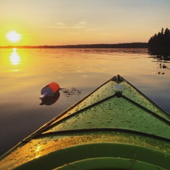
Fundy Footpath – Day 3

Looking to go on an adventure?  Get the gear first!

Visit my gear page here for questions about gear.

1313902.large

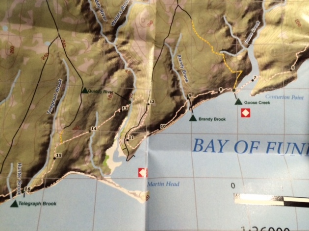
Goose Creek Campsite to Goose River – 7.4 km (4.6 miles)

*NOTE*  An additional 7.9 km (4.9 miles) is required to actually FINISH the trail and get to civilization.  This is the “mandatory approach trail”.  The hike from Goose River to find the approach trail is NOT explained well in the guide, and I recommend reading the bottom for help with navigation. 

Total Day 3 – 15.3 km (9.5 miles)

Total hiked after completion – 49.3 km (30.6 miles) TOTAL.

We made the 9.5 miles by 1 pm, crushing the day, because.. HUNGER!!!  All we could think of was, oh man – the car is right there!  9 miles away.  We can potentially get there at noon and immediately drive to eat the most food ever.  Warm showers were also on the mind.  But first, food.

We had a tough decision to make.  Low tide was scheduled for 6:51 am, we had 2 crossings to make that were 7.4 km apart, with a 4 hour window to make both.  Knowing our previous days hiking rate, and our current exhaustion level, it wasn’t looking good.  However, we had hunger on our side.  I was not about to wait until 5 pm to cross Goose River.  We were up at 5 am, and out of camp by just before 6 am.

img_7220

Crossing Goose Creek sucks.  Neither of us had water shoes, because, who has time for those.  They are too heavy for camp shoes, and I have never really needed them.  I’ve made all my river crossings to date in my boots.  THIS crossing, however, was not sandal friendly.  I immediately lost my first sandal hiking the .5 km up river to the crossing.  The mud came up to our knees.  I didn’t even bother looking for it, I was too tired.  The mosquitos were on us, the rain had started, I was barefoot, and it was only 6 am.


We made it to the crossing, a slow trickle of shallow water.  The rocks were cutting into my feet, I was ready to put on some shoes and get my hike on!  The crossing took about 20 minutes for the minimal distance, which was a little disappointing.

On the other side, however, we went beast mode.  I carry mio energy whenever I hike, which came in handy.  The hike from Goose Creek to Goose River is super easy, comparatively.

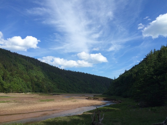
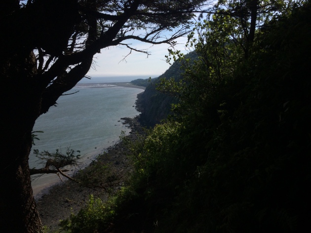
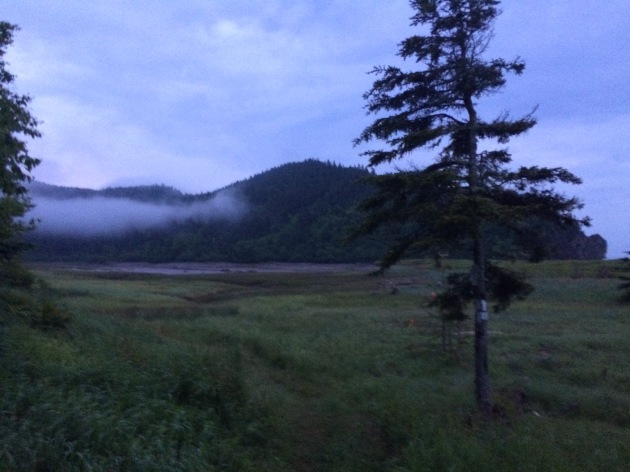
We hiked up and over to Azore Beach, it was raining, but it was still a pretty site.

We got a little worried that we weren’t going to be able to make the crossing, until we came upon 2 hikers that had just crossed it, and said the water was still below their knees.  We ran from there.  We found the river!   We found the 0 km!  It was 3 hours past low tide and the crossing was super easy.  Rock hopping.  Never got wet.  What was all this about in the book then?

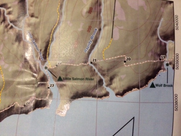
  • NOTE – Well, that’s when things got tricky.  We had to find the approach trail.  We saw some yellow blazes, assumed we were going the right way and walked for a couple hundred yards until it just ended.  We ended up in deep ocean channel, that was just void of water.  There was water in the center, with sloping hills on either side filled with mud, and a high tide water mark well above our heads 20-30 feet on either sides of us.  We realized it was 3 hours past low tide, with the safe crossing gone 1 hour ago, and started to get worried.  With no more blazes visible, panick set in a little bit.

img_7226

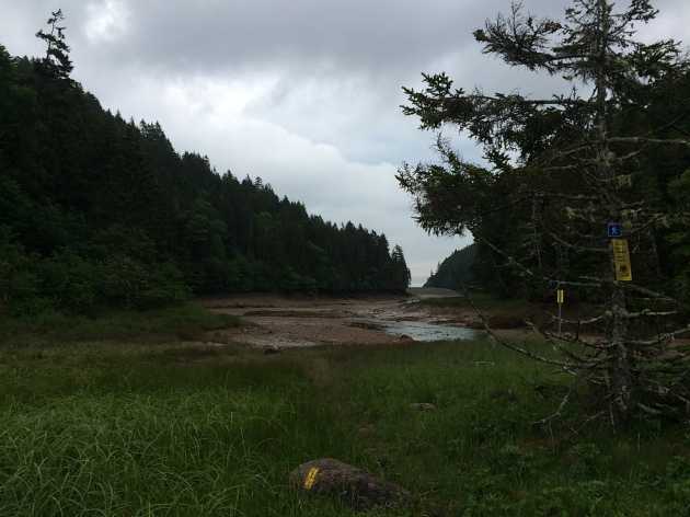
This is pretty much the end of the blazes.  Up ahead, it diverges left and straight.  There are footprints and paths going both ways.  The correct sequence from here is to hike straight, try to keep out of the mud, and once you get to the divergence, go straight across, up the hill, and on top of that hill you will see a log bench and some rocks.  Look very carefully and you will find a poorly marked entrance to the beginning of the approach trail.  The ONLY reason we found this, was because we saw a person.  We had walked around for a good 10 minutes in the wrong direction, and then turned around to try to find our bearings again.  This is not good to do when high tide is looming.  Hope that helps!

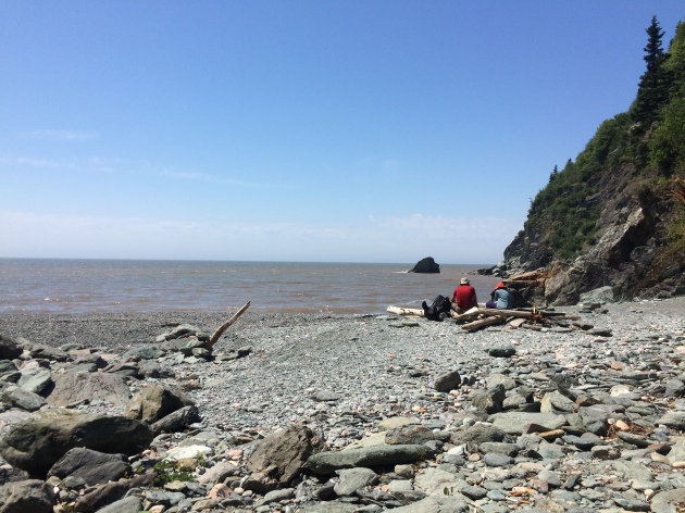
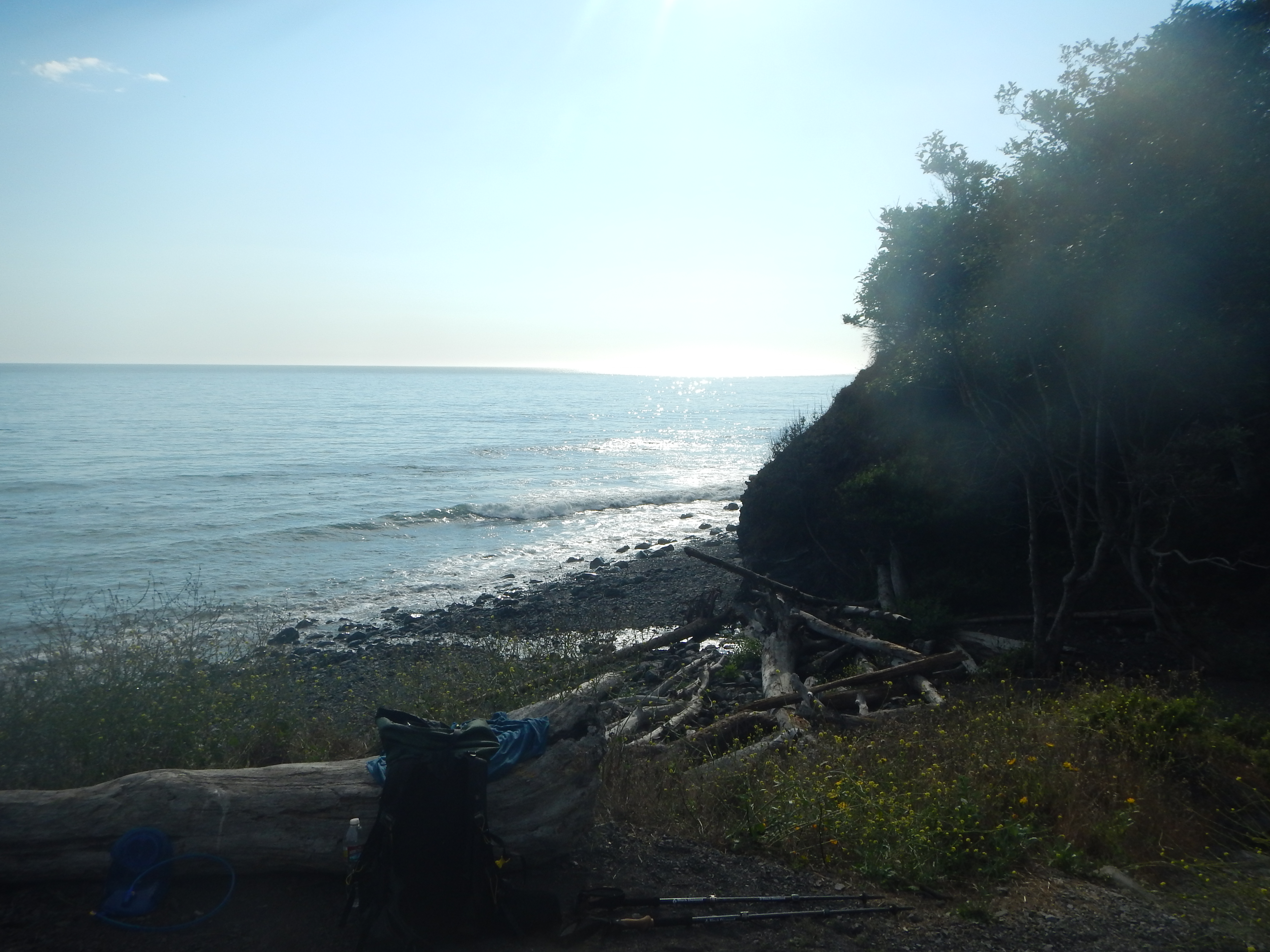
This section is beautiful!!!  And only 7.9 km from our car!!!  Did I mention I was hungry?  What did hot food taste like?  Is there lobster in New Brunsick?  How fast can an injured person run 5 miles with a 40 lb pack?  These are all questions in my mind as I surveyed the awesome scenery.

After taking 30 minutes to find the actual damn trail, we started on it.  IT WAS A ROAD!  We hiked the 5 miles in a little under 2 hours.

The End.  Aaaaand ready for the next one.


Fundy Footpath – Day 2


Little Salmon River to Goose Creek Campsite – 16.1 km.  (10 miles)

Total 34 km (21.2 miles)

IMG_7203

Hell of a day!  We met some Canadian hikers doing the same trail last night, and camped with them.  They told us that today was the hardest section of all.  Today WAS the hardest day.  It was a serious roller coaster of steep, and I mean steep, uphills, marshes on top, steep descents to creeks, up and around inlets etc.  My knee had started aching the day before, so I was a little worried about it.  But hey, we made it.

Section 1 – Little Salmon River to Wolf Brook – 4.5 km (2.8 miles)

image1(1)

4.5 km.  2.8 miles.  For some reason, this took us roughly 3.5 hours!  This section was a rough way to start the day.  We woke up early, and got out of camp at 7 am, proudly packed up everything quick and thought we were going to make it to Azore Beach (we really wanted to stay there).  As you can see, the trail from Little Salmon River goes up an asskicker.  Being that it was only 7 am, we thought we’d beat the heat.  The humidity index went WAY up, and we found ourselves out of breath and taking off clothes near the top.  The top section was murky, swampy, something out of Vermont.   We made it to our first stop at Rapidy Brook, and we realized it took us almost 2 hours to hike the 2.5 km.  There is a really nice bridge here, and a great place to fill up water.

The trip to Wolf Brook was easier, except once again on top, there was a huge swamp.  We were both super tired but the silly talks about food and Canadian Panther Ticks made the journey a little more easy on the feet.

Wolf Brook to Telegraph Brook – 2.0 km – to Quiddy River 6.0 km (10.5 for the day – AND LUNCH!)

Every time we got down to a brook I got all excited!  We are making progress!  And I get to stop and take a long break.  By Telegraph Brook, I was beat!  Everything was hurting.  This was the extremely hard part, and I was in the middle of it.  We were both in shock at this point and sat down and took a good 20 minute break.  We ran into a couple of hikers hiking the other way, they gave us some info about the trail which wasn’t too positive, and had a nice little snack.  I started realizing this was going to be a long day!  Telegraph Brook is a pretty nice place to stop for a break, a nice pool of water.

IMG_7216

I’ll be honest, getting up and hiking after sitting down sucked.  Last thing I wanted to do.  We got to climb up and away from the ocean, back down to another brook, a steep up a mountain, and then drop a swift and very steep descent to Quiddy River.  I was in a lot of pain and in a sour mood by the time we arrived here, and we weren’t making the time I thought we would.  Quiddy River was a GREAT place to take the shoes and socks off and just relax and soak the feet.

Quiddy River to Goose Creek Campsite – 6 km (3.72 miles)  Total for the day – 16.1 km (10 miles).image1(2)

I realized we were going to get to Goose Creek at 6 pm, perfect time for a low tide crossing.  10 hours to hike 10 miles, I was not very happy with.  I felt like since it stayed light out until 10 pm, why not make it to Jim Brook or Rose Brook?  And the answer to that question, is because I zombie walked into Goose Creek, I don’t think I had enough energy to muster up my evening chores!  Getting water for instance.

After the section we just went through, this was not bad at all!  Yes, going up from Quiddy River sucked.  Just to come all the way back down to sea level again, just down the path a little bit.  In fact, I overheard the Canadians talking about walking down that section in their water shoes and skipping the uphill, because the road and ATV trails connect to the actual trail.  We should have waited for them!  The uphill was unrelentless.  The downhill part was awesome, about 2 km of easy downhill.  Unfortunately, this is when my girlfriend started getting the bad blisters.  We had duct taped her feet since her shoes weren’t really broken in when we started (rookie mistake 😉 ).  I have had great success with duct tape.  We were just really beaten down by this part, and we understood we were just going down the same hill we climbed up, only to be about .5 km away from where we started, while hiking about 3.

But those views though!

IMG_7217

The trail meandered along the beach for hours, it seemed to stretch out longer, I felt like this was all the maps fault.  We finally made it to Brandy Brook!   And then hiked the 1 km to our campsite.  Once we got there, 10 hours later, we realized… This is where we are sleeping tonight.  On the plus side, Goose Creek Campsites are dope looking!

The rest of the evening was quite calm if I remember correctly.  Same Canadian neighbors showed up, not many spots to sleep in, but we all fit.  Another bear box at this site.

Interested in your own camping experience?  Check out my lengthy gear page!

Lost Coast Trail – Day 3

Buck Creek to Black Sands Beach (Shelter Cove) – 7.2 miles

Total trip – 28.4 miles

I could have hiked this entire section in one long and arduous day, but I’m glad I didn’t!  The views were too amazing.  This hike to shelter cove was easy.  I was up early admiring the ocean yet again.  This time I got a little antsy and left before everyone else.  I probably left around 8 am, and arrived at shelter cove around 11:30 am.  I really had to poop, so that propelled me into town.  Options for the ol #2 are going where the high tide will sweep it away, or up the creek which was probably everyones water source, and poison oak was everywhere.  I chose to make it to town.

The first thing I realized when I left camp was… I was completely isolated.  There was no one around.  We had been seeing people, a lot of people, over the last couple days.  This morning I felt completely alone, and I loved it.  DSCN1100 DSCN1101 DSCN1102 DSCN1103 DSCN1105

Water sources are a plenty on the Lost Coast Trail, as many streams flow down from the mountains, as the ocean fog will keep replenishing.  At times, this section of the trail was quite rocky.  At other times, you could walk barefoot.  Oh man, I love walking (sorry, “hiking”) barefoot on the beach.

DSCN1106

Barefoot prints

DSCN1108

Time to relax.  No rush, only 7 miles to town, and I am pretty much done by 11 am.

DSCN1109

Roc Doc caught me on the last mile, and we hiked together into Black Sands Beach parking lot with pizza on our mind.  We noticed Shelter Cove was 2 miles up “the hill” as the locals called it.  Screw that, it’s like a 3000 ft mountain.  We hitched a ride into town from one of the local caretakers of the recreation areas and had some lunch at the cash only (only place open) deli.

Everyone else rolled in around 2-3 pm and we paid for a stupid campsite next to the cash only (only place open) deli.  Beer in shelter cove costs $15 for a 6 pack.  This town is not very hiker friendly at all.  So we ignored the weird stares, put up with the grumpy old guy that owns the only wifi in town, and drank as much as we could.

All in all, a good day.

DSCN1111 DSCN1113 DSCN1117 DSCN1123 DSCN1124 DSCN1125

Lost Coast Trail – Day 2

Spanish Flats Campsite  to Buck Creek – 12.8 miles

Total Trip thus far – 21.8 miles

IMG_5628

Wow.  Falling asleep on the beach is just like you imagined it would be like.  Or just like you have done before.  Just like that time you spent in Mexico with your windows wide open, listening to the waves crash, softer and softer until…

6:30 am, and here I am!  It wasn’t a dream!  I am hiking the lost coast trail with some of my best friends from the Appalachian Trail northbound group from 2014.  I woke up early from habit, or the fact that I am doing something awesome and don’t want to sleep through it.  We lounged for about 3 hours, breaking down camp, having breakfast, just being on the beach.  It wasn’t windy today, the sun rose, the air had a slight breeze, it was beautiful.  We hiked for about 3 hours on the beach, real easy hiking, until we hit Millers Flat.  We decided that since the next mile was impassible at high tide, which was in a couple hours, that we would take a lunch nap.

DSCN1062

Morning hike!

11822727_10206944697917794_9051160185547570832_n

Stopping for some much needed water

DSCN1065

From whence we cameDSCN1067

Stopping for some water

DSCN1069

Lunch nap

As you notice, I am in the shade.  There is really no escaping the sun on the first part of the Lost Coast Trail.  While that’s not a bad thing, I was getting pretty red, and needed a nap in the shade.  We hung out here for about 2-3 hours, swimming in the small pond, combing the beach.  It was chill.

When we moved on, we came upon a bunch of hikers that were waiting for the high tide to roll out.  The waves were just crushing the cliffs and we would not be able to walk for another hour.  So we hung out some more on the beach…

11204469_10206944699277828_7262028423113152344_n

Once the tide rolled out, we meandered on.  We left a little too early, and had to run between wave sets, sometimes having to climb up the cliff to get out of the way.  I could see how this could become hazardous (especially at night).

11781779_10206944697077773_409829986410746600_n  DSCN1070 DSCN1075

Pretty soon I stumbled upon this group of birds, and the smell was.. well, ominous.  I feared something dead.

DSCN1077 DSCN1078

Yarrr, t’was a beached whale!  We found out from talking to people later in shelter cove, that it had been a floater for a couple months and then had been beached on the Lost Coast.

We arrived at another one of the BEST CAMPSITES EVER, seriously.  Camping on the beach is awesome.  I set up my tent, took pictures of my tent set up to prove that I had indeed set up my tent, and then murdered my dinner.  The whale far from my mind, my mind soaking in the view.  We all hung out til around 9 (sun sets at 8:40pm up there) and it got a little chilly.  Another perfect sunset.  More beautiful stars to look up at.  Who’s idea was this?!  Mine.

11038011_10206944700317854_549612281903450350_n

Watching the sunset with the gangDSCN1079

I think I’ll pitch a tentDSCN1080

And then take a pictureDSCN1087

Sunset!

DSCN1091 DSCN1095

My favorite picture

DSCN1098

I eventually fell asleep just staring out at that sky, feeling so blessed to be able to do something this amazing.

Lost Coast Trail – Day 1

Matthole Beach to Spanish Flats Campsite – 8.4 miles

After a good night of having a couple drinks, reuniting with long lost trail friends, etc. we were a little achy.  We had arranged a shuttle to pick us up and drive us to the northern terminus of the Lost Coast Trail, as we had parked at the southern terminus, and would hike back.  The shuttle was Lost Coast Adventures.  The drive is 3 hours to matthole beach, there is no easy way to get back and forth, so we chose to shuttle.  For around $300 for the 6 of us, we had a solo hiker join us and hop on in.  The shuttle driver was awesome, drove us through the redwoods, told us the history of the land and eventually we arrived at Matthole beach.

IMG_5613

We were at Matthole beach around 1pm.  The wind was wicked, and it stung.  A lot.  Luckily I had bought some cheap sunglasses at a gas station just outside of SF.  I was fully lubed with SPF and had my stunner shades on, I was ready.  We ate lunch, however and hung out hiding from the vicious winds for an hour.  And then… we started.

DSCN1024 DSCN1026 DSCN1027 DSCN1028 DSCN1030 DSCN1031 DSCN1032

Sick.  Like, so sick.  Call out of work sick.  So beautiful, I don’t need to write words about it.  Just show some pictures.  This blog is easy.  In fact, this trail was easy.  Sand in your shoes and in your eyes and in just about everything you can imagine.  That is a good problem to have, in my point of view.  We breezed through the first section, against the stinging winds that hit us like an angry hail storm.  I took way too many pictures.  Eventually we hit Punta Gorda Lighthouse.  I thought I saw some dead sea lions, and then DSCN1035 DSCN1036 DSCN1041

They’re ALIVE!  We just stared at them and then had an epiphany…. Nap time!

lounging

After this, the hiking was so easy we just breezed passed the first campsite, as we passed almost 20 hikers heading the same way.  Ever since the Appalachian Trail, crowded campsites give me the heebeejeebies.  No thanks!  So we left a message for our slower hikers that we crept on, and wrote them a big beautiful trail sign in the sand.  Because – we’re on the beach and we HAVE TO play in the sand.

We made it to Spanish Flats with enough time to set up camp, eat, and watch the ever so slooooowwww sun set.  This might have been the most beautiful place I have ever camped at.  Don’t believe me, just watch.

DSCN1050 DSCN1053 DSCN1055 DSCN1056 DSCN1058 IMG_5616 IMG_5618 IMG_5624 IMG_5625 IMG_5627

Lost Coast Trail – Getting lost and getting there (Usal Beach Campground)

It is important to note that you will get lost, trying to find the Lost Coast Trail.  It is also important to note, that the 6 miles of dirt road will cause you to leave with a collapsed motor mount, and cracked suspension of your 2008 Nissan Altima.  DSCN1023

The drive from San Diego to Usal Beach Campground was awesome, and awful at the same time.  I was so hungover leaving San Francisco, but so distracted by the beauty of the 1 that I was just confused of what to feel.  I was so hungover, in fact, that I forgot to print the directions to get to Usal Beach campground.  This link should help you get there. I didn’t read the part about the dirt road at mile 90.88 on highway 1 after leaving Leggett.  I also didn’t realize I would have zero cell phone service at all.  Neither did I realize that there would be no signs pointing you in the right direction.  Not one.  I drove all the way to Westport Beach.  I was hungover, and confused.  I finally got 1 bar of reception around Westport Beach and quickly looked up how to get there.

Heading SOUTH on the 1 from Leggett, find mile marker 90.88, and turn right onto Usal road (unmarked).  Since I was now heading North from Westport to Leggett, I found the mile marker and turned left.  I made it to the road!

The road was my worst nightmare.  I bottomed out too many times to count.  A big ol truck would have been helpful.  My 4 door sedan was screaming at me.  I quote “Usal Road is a narrow, winding, sometimes steep dirt road that was at one time a part of the stage line between San Francisco and Eureka. During the rainy season this road is impassable for most vehicles and is not recommended for trailers or large RV’s anytime of the year.”

I finally made it down the 6 miles to the vague and unmarked campground to find a TON of people just absolutely raging down there.  Still no service.  I was meeting 6 people there, and was concerned that I might never find them.  I was in the twilight zone.  But it was beautiful!

IMG_5605 IMG_5611

After driving around for 20 minutes, I found GOAT and Roc Doc awaiting me.  They had not brought beer (mistake) but I did (hero).  We started chugging and laughing about how terrible the road was to our cars, and if we would find Gandalf later on.  We made a sign out of a piece of notebook paper and a pen, which was illegible and unnoticable if you were in a moving car.

However they found us, we were all reunited, we drank, shared stories, and mentally prepared for the next week.  We were finally at Usal Beach Campground, and tomorrow – we would be starting our adventure on the famed Lost Coast Trail!IMG_5606 IMG_5608 IMG_5609

Road Trip – Part 2 – Grand Forks, ND to Olympia Beach Park – Washington

IMG_4094 IMG_4100 IMG_4101 IMG_4104 IMG_4113 IMG_4119 IMG_4127 IMG_4140 IMG_4142 IMG_4145 IMG_4146 IMG_4156 IMG_4158 IMG_4166 IMG_4175 IMG_4186 IMG_4188 IMG_4193 IMG_4201 IMG_4204 IMG_4205 IMG_4210 IMG_4211 IMG_4216 IMG_4222 IMG_4226 IMG_4227 IMG_4228 IMG_4230 IMG_4232 IMG_4233

6500 mile Road Trip – Part 1 – Maine to Grandforks, North Dakota.

I found myself in heaven after a while.  3-4 weeks had passed since I had finished my hike, and I was bouncing between Cushing Maine (and that big beautiful comfortable vacation house that I wish was mine) and New Hampshire with the girl I was hanging out with, and Swazey was ALWAYS at a beach.  IMG_4018

But it came down to the point where summer was winding down, and I knew I was running low on funds.  I still had to drive back to Phoenix (gas money, places to stay, food) and I also had only rented out my house until September 1st.  For me, there were 2 ways to go home.  Straight to Phoenix, which would be a no fun 3 day road trip.  OR a spur of the moment whatever I felt like road trip, where I could camp everywhere and go see places like the Redwoods!  OH and I have never been north of Santa Barbara California!  Whaaaaaat.  I knew I wanted to go to the Northwest.  Guy on a Buffalo (a fellow thru-hiker) offered me a place to stay in Olympia Washington, so I vaguely knew where I was going.

I put the dog in the car, said bye to my super amazing parents, my friends, and the East Coast.  I stopped down in Hartford Connecticut for lunch to see my friend Monika who I NEVER get to see because she just moved back from Italy, and set my sights on Ohio.  I didn’t know where I was going, I just knew how long I wanted to drive.  I picked a town not far away and googled campgrounds near it.  I found an AWESOME one, no idea of the name.  I instantly met a guy fishing with loud music drinking beers and made him my best friend for the day.  He let me fish with him, we caught 3 bass, he taught me how to filet the fish and then we cooked them over a camp fire.  I found out he was living at the campground for the last 6 months, because he likes being outside.  He works as a metal welder but just liked camping.  I love his style.

IMG_4023 IMG_4024 IMG_4026 IMG_4027 IMG_4030 IMG_4034

The next morning, I awoke to the most BEAUTIFUL sunrise over the fishing pond.

IMG_4039  Friggin surreal right?!  Damn I love camping.  So I did a little digging with my phone.  I found a GREAT website for car camping.  Did you know you can car camp the entire US for FREE?  I didn’t.  I paid $15 for that campsite the night before.  But that was literally the last one for a while.  www.freecampsites.net allows you to input a destination, and find FREE campsites within 50 miles of your destination.  They also post paid campsites if you want to be a snob.  Some paid sites are really dope of course.  This was the greatest information ever!  I wish someone had told me about this long ago.  I found some of the most remote and beautiful campsites because of this website.

Anyways, I b-lined it to Cedar Rapids Iowa next, because why not?  Also I have a lot of friends there.  I ended up staying there for about 3-4 days for free on someones couch and it was just a giant binge drinking week.  Swazey loved it too,

IMG_4040 IMG_4041 My favorite B’s in Iowa.

For my next trick, I decided to take a guy (another thru hiker I met on the trail, named Uffda) up on his offer for me to come crash at his place in Grand Forks, North Dakota.  Shit, I had never been to North Dakota, so why not?!?  PLUS, it takes me right through Minnesota, and there is another place I’ve never been to…  I found the dopest dog park outside of Minneapolis using yelp or something like that, it was 25 acres with huge lakes and all that.  Swazey went nuts and got very very dirty.

IMG_4042 IMG_4045

Now that I had mud in my car, I moved on.  The sky was beautiful on and off, rainstorms in the distance, or sometimes on top of me.  BUT I WAS IN A CAR!  HA!  Take that mother nature!  (Hiking the Appalachian Trail had mother nature making me its bitch).  IMG_4050 IMG_4056

Well, I made it to Grandforks, and Uffda showed me the hockey stadium that city is apparently famous for.  It’s called the Taj Mahal of hockey, and cost $104 million dollars to build.  Former NHL hockey player Wayne Gretzky has called the structure “one of the most beautiful buildings we have in North America”.  So what the fuck, I went and saw it.

IMG_4058 IMG_4059

Cash Money!  This road trip is a blast, and is a lot to share… SOOOOOO I will write more about it soon!

Day 58

Catawba Mountain Shelter to Fullhardt Knob Shelter – 22.8 miles
729.0 / 1456.3

We made it through the Vortex that is Daleville, Virginia! So proud. Didn’t even stay longer than 2 hours. Some people never stood a chance.. They are still there.

Since we camped 1.9 miles before the beautiful and poetic ‘Mcafees Knob’ we decided to wake up at 5:30 and just go for it, sunrise and all. And it was so worth it! I shot what one youtube user said was the ‘best shot of Mcafees Knob this year’. It was that good. This picture is also now viewable at Three Pigs BBQ because he owner Bill has great taste in photos. Check it out.

20140506-201412.jpg

Right?? So anyways, we chilled there for a long time watching the sunrise, before eventually moving on. Since its time to put on miles again and since fresh had a package to pick up, we flew the 18 miles into town by 1:30. The hiking was easy but got very hot as it was 77 out and super humid. We walked a stretch past barren land with power lines and another stretch across highways and it was brutal!

We are now camped out and full. For lunch I had a large pepperoni pizza at little Caesars and 2 20 oz sodas, went to three pigs BBQ and had wings, and then a frosty from Wendy’s. Yup! Nothing like $20 lunches at cheap places. Enjoy the photos.

20140506-202003.jpg

20140506-202023.jpg

20140506-202013.jpg

20140506-202032.jpg

Grand Canyon – Havasu Falls – Part 2

We set out for this 3 day Grand Canyon adventure knowing the weather conditions were going to be cold and wet.  I had a couple new items of my gear for the Appalachian Trail that I was eager to test out (Ill get to that later).  It was forecasted for 48 degree high and 28 degree low with rain.  The drive is about 5 hours so we usually stay in a motel about an hour or 2 from the trail head.  We departed at 7:30 am after breakfast and it started raining/snowing on the drive there.

IMG_1344

The parking lot and down was a little better.  It was 34 degrees, so no snow, but it was lightly raining.  We descended the 10 miles to our campground

100_0556 100_0564

We arrived around 4pm, the sun was already behind the cliffs, and it was cold.  We wandered down to mooney falls to see if the camping spot I have had my eyes on was open, and there it was!  Open.

IMG_1351       IMG_1383a

It’s located just to the right of the falls, if you are looking at the falls.  We set up camp, ate, and went to bed because it was cold!

We slept in, til about 8:30 today. My hat was over my eyes so I had no idea it was morning. I actually thought I turned on my headlamp and tried turning it off, only to find it was daylight. I opened my tent, remembering that I was on the top of the waterfall and lay there for a while looking out. And there was a rainbow. Seriously?

IMG_1483

It was very relaxing, we had the entire campgrounds to ourselves. I got out of my tent to a temp in the 30s, made my way to the bathroom, and got us all water. It’s about a 10 minute walk from the top of mooney falls where we camped to the water station, and it was nice to not see anyone . Strange, but nice. Some couple coffees and oatmeals later, we had lounged for about 3 hours. It was warmed up to the high 40s, 48 had been the forecast.

IMG_1410  I tried out my iPhone 5s video slow mo here – pretty cool.  https://vimeo.com/80515139

We departed for the bottom of mooney falls around noon. It was a cliffhanger, literally. They put ladders and chains down but the mist from the waterfall made it treacherous. It was thrilling, wet and cold. My gloves were soaked from the climb down. We stayed about 30 minutes at the bottom and hiked up to havasu falls. A group of Asians were there just absolutely murdering that waterfall with photography. I stripped down to my shorts and suddenly all lenses were pointed at me. Waded out and jumped in, invigorating! It was probably 45-50 degrees out so it took awhile to warm up.

IMG_1461    IMG_1484 (Don’t be fooled, it’s in the 40’s, the water is always 67 degrees-ish though!)

When we were all dry we headed to the top of the falls to see if we could steal some sunlight, but it was already behind the canyon.. I headed back to campsite, threw on some sweats, ate dinner and the we drank some jack and played cards. Goodnight!

Waking up Monday was surreal, the sun was shining, it became 50 degrees and we set for the top of the cliff.  Made it up after about 5.5 hours.

The gear I had recently purchased and got to use –

MSR Hubba 1p tent – rainfly worked perfectly did not get wet

Thermolite reactor 20 degree synthetic bag liner – I had a 40 degree sleeping bag, and was able to keep warm during the cold nights, great purchase.

Thermarest Neoair Xlite regular (12 0z) Sleeping pad – Seriously light and small, I have heard complaints about it being noisy, but we were camped next to a waterfall, couldn’t hear anything.  Did well in the cold, comfy!

Rain jacket – Patagonia Torrentshell – No complaints, was able to keep baselayers of smart wool and just this jacket to keep warm.  Kept dry til I went swimming!

Still have a lot of work to do/gear to get before hitting the trail in March, but this was a nice exercise in the cold!