Top Backpacking Tents of 2016

So you’re ready for some backpacking, and want to start with the basics.  Or maybe you’re experienced and looking for some new gear for that new trip you have lined up.  Having a top notch tent in your pack is one of the best ways to increase comfort, enjoyment and safety on backcountry trips.  But when you are starting to look for your new tent, you will find there are A LOT of options out there.  Trying to find the tent that fits your needs can quickly become overwhelming.

I’m kind of a gear-head.  I love my research.  And having thru-hiked the Appalachian Trail and many other trails, I have the opportunity of knowing THE BEST people to ask when it comes to gear selection.  Not only that, but during my own hiking experiences, I’ve researched and tested, got referred to many various backpacking tents, and narrowed them down to the very best of the best.  Weight, cost, interior space, and weather protection are all factors in my choices.

I hope this post helps you find the best tent to suit your needs, keeping you warm, dry and protected in the outdoors for many years to come!
IMG_4101Shwayzes Gear Guide: Tents.

Tent considerations

Cost – Cost is one of the biggest concerns for most people.  You shouldn’t have to pay a small fortune for a tent.  However, as most of you know, a little more money spent on a quality product protects you from various and unforseen setbacks encountered.  Preparation is key.

Weight – A few ounces here and there seem like nothing before the trip.  However, they add up and become consequential when you experience fatigue, knee pain, etc.  Keeping your pack light is the #1 priority to stay healthy on long trips.  I have seen too many injuries due to heavy packs in my time.  To me, weight is critical.  As one of the big 3 (heaviest items in your pack – tent, sleeping bag, sleeping pad), it’s essential to keep weight to a minimum with these items.

Protection – A backpacking tent that doesn’t protect you against mothernature is just dangerous.  I backpacked with a couple that bought a $40 tent, and when the temperature dropped, they suffered.  They also didn’t fair so well during rainstorms either.  Be careful with extreme budget tents.  Every tent on this list will keep you well protected from the elements.

Season Rating – Where are you hiking and how long?  What kind of conditions are you expecting.  Expect the unexpected.  3 season tents are the most popular, built for spring summer and fall trips.  I’ve survived some winter hiking with my 3 season, when it dropped down to 13 degrees at night with some wind.  I had a great sleeping bag, but that’s a different list.  A good 3 season tent will have you isolated from bad weather, while still promoting air circulation on those hotter days.

Interior Space – Comfort, really.  If you’re 6′ 3″ and your feet are touching against the end of the tent, you’re going to get wet.  Including your sleeping bag.  This is important to strike a balance between comfort and weight.  I have chosen tents that maximize interior space, while keeping weight at a minimum.  I like a spacious light weight tent, so I carry a 2p.  If you are willing to carry a little extra weight, consider bumping up a size.

Capacity – How many people will you be traveling with?  2 person tents are the most popular, and for good reason.  With recent tech designs and innovations, tent weight has been decreasing drastically, allowing a single person to carry a 2 person tent.  There is not much difference in weight between a 1p and 2p tent.  Group tents are heavier and less practical, and more meant for car camping.  However, there are some good options I have listed in another section.

Durability – Light weight tents tend to be less durable than heavy weight tents.  However, unless you are really rough with your gear, the tents I have provided in this list will last you many years, and thousands of miles.  My current tent has lasted around 3000 trail miles, and there is absolutely nothing wrong with it.  Flawless.  My experience and research have shown me that if you treat a light weight tent well enough, they will last you thousands of miles, many more miles than the average backpacker.  My professional opinion is to stick with the light weight tents.

Wall Construction – This gets a little too specific, but is important.  Double wall tents come with 2 separate walls, the tent itself, and a rainfly.  The advantage to this is that condensation will stay off the mesh inner wall, and stick to the rainfly.  The other advantage is simply airflow on a cloudless night.  Keep it on to stay warm, take it off when it is hot.  Single wall tents have a built in rainfly, saving a little weight, and promote airflow to keep condensation down.  However, condensation is inevitable, and when your sleeping bag gets soaked because of it, your next day is going to be rough.  My opinion is to stick with a double wall tent.

Doors/Vestibule Space – Having 2 doors is helpful when 2 people are sharing a tent.  As well as 2 vestibules.  A vestibule is the space under the rainfly, between the tent and the rainfly, that you can keep gear in to prevent from getting wet, but also don’t have to cram into your tent.  Vestibule space is very important to me.  The tents I have listed are proven to fit all your needs, and are quite spacious.

Set up – Freestanding tents have the ability to be pitched anywhere, pop up tents are a synonym.  They can be anchored down with stakes, and even into rock.  These are generally preferred due to ease of set up, and how quick they can be set up and broken down.  Non-freestanding tents use trekking poles or other methods to pop the tent up.  They save weight by not needing tent poles, instead using line, trekking poles, or stakes.  These are a little more time consuming, but I have met some hikers that absolutely love them.  The weight is a huge plus for these.  My preferred tent is a freestanding pop up tent.

Footprint – A footprint weighs next to nothing, and is what interferes with the ground touching the bottom of your tent.  It is extra weight, but will protect your tent from abrasions, rocks etc.  These are sometimes not included in tents, but are worth the purchase, and will be sold as an accessory to the tent.  I recommend footprints just due to how grimy the ground can get.

Buy Online – Although I prefer to buy online because I can shop around for the cheapest deal, not all do.  Check the sellers status before making a purchase, and ask about their return policy.  If you are unsatisfied with your purchase, simply return to the seller.  BUT, the advantage to this, is you are able to purchase the tent, and try it out on your own, before making the decision to keep it.  I’ve purchased my tents online, haven’t had problems and always have ended up keeping them.  But not before doing my diligent research.
img_5805

Best Backpacking Tents of 2016

MSR Hubba Hubba Nx

Weight3 lb. 7 oz.

Dimensions:  84″x 50″ floor, 39″ height

Design:  2 person, 3 season, freestanding, 2 doors, 2 vestibules, double wall.

Features:  Set up and take down is made easier with a color coded hub and pole system.  Two large StayDry™ doors ensure water does not drip into tent while doors are open (I never tried this during a real rain storm).

Uses:  Ultralight backpacking, Backpacking, Camping

A very popular item among ultralight backpackers for a long time, this tent is partial to me, because I carried it with me as I thru-hiked the entire Appalachian Trail (2185.3 miles).  I STILL have it.  A rectangular floor and symmetrical shape allows hikers to spread out on opposite ends.  The vertical side walls and end walls help maximize the interior.  It is super easy to set up and take down, the vents help stay cool on hot nights, and the rain fly provides maximum protection against the elements.  Although it is a bit heavier than other tents I have listed, the durability, design and popularity puts it on this list.

Accessories:  I recommend picking up the MSR Hubba Hubba Nx footprint to increase durability.  The tent is available in different sizes, the Hubba Nx 1p, Motha Hubba Nx 3p, and the Papa Hubba Nx 4p.

Big Agnes Copper Spur UL2      

Weight:  2 lb. 13 oz.  Fast Fly Weight:  2 lb. 1 oz.

Dimensions:  Floor – 29 sq. ft. – 90″ x 52″/42″.  (Wider at head, narrower by feet).  Vestibule – 9 + 9 sq. ft.  Height – 42″.

Design: 2 person, 3 season, freestanding, 2 doors, 2 vestibules, double wall.

Features:  2 doors and 2 vestibules with 18 sq. ft. of vestibule space!  A crossover pole for extra headroom.  Double twisted thread for durability.  All seams are sealed with waterproof, solvent-free polyurethane tape.

Uses:  Long distance backpacking trips, ultralight backpacking, camping, section hiking, weekend warrior

The Big Agnes Copper Spur UL2 packs a solid punch for such light weight.  Although light in weight, it has double twisted thread for extra strength and durability.  Opposing mesh doors provide good ventilation, while allowing 2 people easy access to the tent.  A spacious accommodation for 1 person, but sleeps two in a pinch.  A good friend thru-hiked the Appalachian trail with this, and highly recommended this tent.  It has built in mesh pockets for your gear.

Accessories:  I recommend the Big Agnes Spur UL2 Footprint for extra durability.   This tent also comes in a 1 person UL1  (2 lb. 3 oz.), a 3 person UL3 (3 lb. 11 0z.), and the four person UL4.

Nemo Hornet 2p Tent               

Weight: 2 lb.

Dimensions: Floor – 28 sq. ft.  85″ x 51/43″ (Larger at head, than at foot).  Height – 40″.  Vestibule space – 8 sq ft. x 8 sq ft.

Design: 2 person, 3 season, freestanding, 2 doors, 2 vestibules, double wall.

Features:  Large side doors, a good amount of vestibule space, offers easy access in and out of tent.  Extremely fast and easy set up, thanks to single hubbed pole, with ball and socket tips.  Tech:  Durable, featherlite NFL aluminum poles weigh less than nearly all poles on market.

Uses:  Ultralight backpacking, Thru-hiking, Long distance hiking, Backpacking, Camping.

The Nemo Hornet 2p Tent is one of the lightest freestanding tents on the market.  This is due to the technology used in its design.  Light weight, yet still quite durable.  The downside is less headroom than some of the other tents, but the plus side is it is a lot lighter, making this one of the top tents on the market.  A couple more ounces than its 1p. version, but with an extra door and extra space, it is well worth the upgrade.

Accessories:  I recommend picking up the Nemo Hornet 2p Footprint for extra durability. This is also available in a smaller Nemo Hornet 1P tent.


ZPacks Duplex                  ultralight-two-person-tent-duplex-angle_l
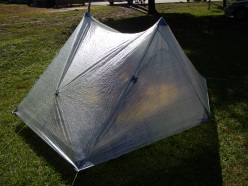
Weight:  1 lb. 5 oz.  (without poles)

Dimensions:  Floor – 90″ x 45″.  Height – 48″.  Vestibule space – 20.75″ on each side.

Design:  2 person, 3 season, 2 doors, 2 vestibules, single wall, 2 trekking poles and 6 stakes min. for setup.

Features:  Set up with two trekking poles to a peak height of 48″.  4 storm doors.  Tarp overhangs floor by 4-5 inches on each side to prevent water from dripping onto floor.

Uses:  Ultralight backpacking, long distance backpacking, backpacking, camping.

Hiking the Fundy Footpath

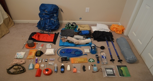
Before you start planning, make a gear list!  I have mine accessible at this link.  This is the gear list I had for the Appalachian Thru-hike I completed, and my gear does not deviate much from it.  I would not bring the cold weather gear, as it is not applicable on the Fundy Coast.

Gear page

01_ATgear_olivier_750x400

Hiking the Fundy Footpath is beautiful, remote, challenging, and inspiring.  But above all else, it’s an adventure!  I did a ton of research before setting out on this one, and I have written most of my findings.  The Getting prepared section has some brief information.

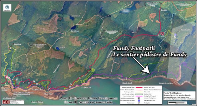
745_403_footpath_map_2009b

Maps can be purchased through this link – http://www.fundytrailparkway.com/en/the_fundy_footpath/ 

*Hint (Literally call them and request one, contact information under “contact us”).  If you are feeling ambitious, you may also ask them about taxis, I have a couple listed under Day 1.

Getting prepared

Day 1 has all the information about where we got our maps, who we picked to take for our taxi and a way to reach them, where to park etc.  People usually leave their car at Point Wolfe Campground which is 8 km from the start (or end) of the trail.  We left our car there and taxid to the other terminus (Big Salmon River).

Day 1 – Big Salmon River to Little Salmon River 17.9 km (11.12 miles)

p1040098

After realizing this hike was a little more challenging than originally anticipated, which is fine for me, I had a minor melt down on day 2.  We hiked only 10 miles, but that literally took 10 hours.  I haven’t hiked that slow in God knows how long, but what a day!  There are shots of the trail and images of the map in day 2.

Day 2 – Little Salmon River to Goose Creek campsite – 16.1 km of hell (10 miles)

Day 3 we were pretty much wiped, and finished the trail by 10 am.  2 days and 4 hours.  Not bad!  But the real reason we hurried on day 3 was hunger and the thought of hot food and all those lobster rolls all around the area.  New Brunswick has some AMAZING seafood.

This section also has some information and pictures regarding finding the end of the trail, as you cross Goose River, crossing over into the approach trail.  They don’t exactly interconnect immediately, and you may want to read about it before hand.  The map wasn’t exactly informative.

Day 3 – Goose Creek Campsite to Goose River (ending) to Point Wolfe Parking Lot – 15.3 km (9.5 miles)

Afterwards, we opted out of the immediate hot showers available at Point Wolfe Campground, and instead traveled to Alma 5 minutes away.  Alma is a quiet little touristy town chalk full of seafood. Here is some info on Alma, although I found asking locals was the best way to get what I wanted.

http://www.tourismnewbrunswick.ca/Products/V/Village-of-Alma.aspx

Fundy Footpath – Day 3

Looking to go on an adventure?  Get the gear first!

Visit my gear page here for questions about gear.

1313902.large

Goose Creek Campsite to Goose River – 7.4 km (4.6 miles)

*NOTE*  An additional 7.9 km (4.9 miles) is required to actually FINISH the trail and get to civilization.  This is the “mandatory approach trail”.  The hike from Goose River to find the approach trail is NOT explained well in the guide, and I recommend reading the bottom for help with navigation. 

Total Day 3 – 15.3 km (9.5 miles)

Total hiked after completion – 49.3 km (30.6 miles) TOTAL.

We made the 9.5 miles by 1 pm, crushing the day, because.. HUNGER!!!  All we could think of was, oh man – the car is right there!  9 miles away.  We can potentially get there at noon and immediately drive to eat the most food ever.  Warm showers were also on the mind.  But first, food.

We had a tough decision to make.  Low tide was scheduled for 6:51 am, we had 2 crossings to make that were 7.4 km apart, with a 4 hour window to make both.  Knowing our previous days hiking rate, and our current exhaustion level, it wasn’t looking good.  However, we had hunger on our side.  I was not about to wait until 5 pm to cross Goose River.  We were up at 5 am, and out of camp by just before 6 am.

img_7220

Crossing Goose Creek sucks.  Neither of us had water shoes, because, who has time for those.  They are too heavy for camp shoes, and I have never really needed them.  I’ve made all my river crossings to date in my boots.  THIS crossing, however, was not sandal friendly.  I immediately lost my first sandal hiking the .5 km up river to the crossing.  The mud came up to our knees.  I didn’t even bother looking for it, I was too tired.  The mosquitos were on us, the rain had started, I was barefoot, and it was only 6 am.


We made it to the crossing, a slow trickle of shallow water.  The rocks were cutting into my feet, I was ready to put on some shoes and get my hike on!  The crossing took about 20 minutes for the minimal distance, which was a little disappointing.

On the other side, however, we went beast mode.  I carry mio energy whenever I hike, which came in handy.  The hike from Goose Creek to Goose River is super easy, comparatively.

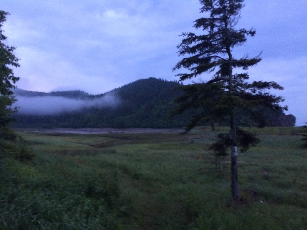
We hiked up and over to Azore Beach, it was raining, but it was still a pretty site.

We got a little worried that we weren’t going to be able to make the crossing, until we came upon 2 hikers that had just crossed it, and said the water was still below their knees.  We ran from there.  We found the river!   We found the 0 km!  It was 3 hours past low tide and the crossing was super easy.  Rock hopping.  Never got wet.  What was all this about in the book then?

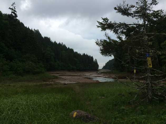
  • NOTE – Well, that’s when things got tricky.  We had to find the approach trail.  We saw some yellow blazes, assumed we were going the right way and walked for a couple hundred yards until it just ended.  We ended up in deep ocean channel, that was just void of water.  There was water in the center, with sloping hills on either side filled with mud, and a high tide water mark well above our heads 20-30 feet on either sides of us.  We realized it was 3 hours past low tide, with the safe crossing gone 1 hour ago, and started to get worried.  With no more blazes visible, panick set in a little bit.

img_7226

This is pretty much the end of the blazes.  Up ahead, it diverges left and straight.  There are footprints and paths going both ways.  The correct sequence from here is to hike straight, try to keep out of the mud, and once you get to the divergence, go straight across, up the hill, and on top of that hill you will see a log bench and some rocks.  Look very carefully and you will find a poorly marked entrance to the beginning of the approach trail.  The ONLY reason we found this, was because we saw a person.  We had walked around for a good 10 minutes in the wrong direction, and then turned around to try to find our bearings again.  This is not good to do when high tide is looming.  Hope that helps!

This section is beautiful!!!  And only 7.9 km from our car!!!  Did I mention I was hungry?  What did hot food taste like?  Is there lobster in New Brunsick?  How fast can an injured person run 5 miles with a 40 lb pack?  These are all questions in my mind as I surveyed the awesome scenery.

After taking 30 minutes to find the actual damn trail, we started on it.  IT WAS A ROAD!  We hiked the 5 miles in a little under 2 hours.

The End.  Aaaaand ready for the next one.


Fundy Footpath – Day 2


Little Salmon River to Goose Creek Campsite – 16.1 km.  (10 miles)

Total 34 km (21.2 miles)

IMG_7203

Hell of a day!  We met some Canadian hikers doing the same trail last night, and camped with them.  They told us that today was the hardest section of all.  Today WAS the hardest day.  It was a serious roller coaster of steep, and I mean steep, uphills, marshes on top, steep descents to creeks, up and around inlets etc.  My knee had started aching the day before, so I was a little worried about it.  But hey, we made it.

Section 1 – Little Salmon River to Wolf Brook – 4.5 km (2.8 miles)

image1(1)

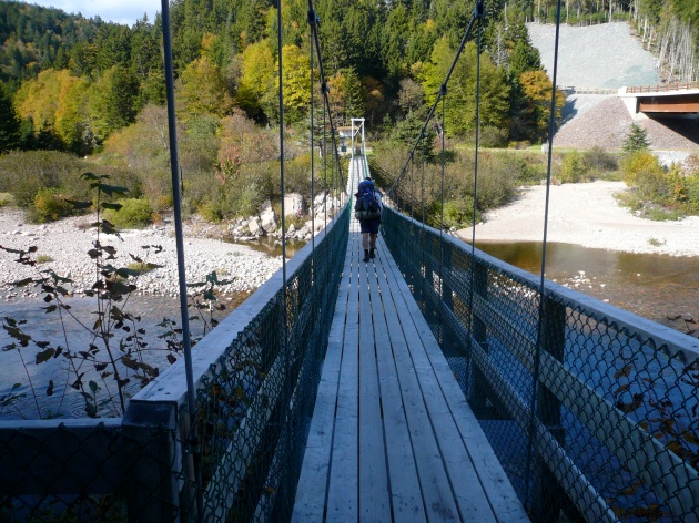
4.5 km.  2.8 miles.  For some reason, this took us roughly 3.5 hours!  This section was a rough way to start the day.  We woke up early, and got out of camp at 7 am, proudly packed up everything quick and thought we were going to make it to Azore Beach (we really wanted to stay there).  As you can see, the trail from Little Salmon River goes up an asskicker.  Being that it was only 7 am, we thought we’d beat the heat.  The humidity index went WAY up, and we found ourselves out of breath and taking off clothes near the top.  The top section was murky, swampy, something out of Vermont.   We made it to our first stop at Rapidy Brook, and we realized it took us almost 2 hours to hike the 2.5 km.  There is a really nice bridge here, and a great place to fill up water.

The trip to Wolf Brook was easier, except once again on top, there was a huge swamp.  We were both super tired but the silly talks about food and Canadian Panther Ticks made the journey a little more easy on the feet.

Wolf Brook to Telegraph Brook – 2.0 km – to Quiddy River 6.0 km (10.5 for the day – AND LUNCH!)

Every time we got down to a brook I got all excited!  We are making progress!  And I get to stop and take a long break.  By Telegraph Brook, I was beat!  Everything was hurting.  This was the extremely hard part, and I was in the middle of it.  We were both in shock at this point and sat down and took a good 20 minute break.  We ran into a couple of hikers hiking the other way, they gave us some info about the trail which wasn’t too positive, and had a nice little snack.  I started realizing this was going to be a long day!  Telegraph Brook is a pretty nice place to stop for a break, a nice pool of water.

IMG_7216

I’ll be honest, getting up and hiking after sitting down sucked.  Last thing I wanted to do.  We got to climb up and away from the ocean, back down to another brook, a steep up a mountain, and then drop a swift and very steep descent to Quiddy River.  I was in a lot of pain and in a sour mood by the time we arrived here, and we weren’t making the time I thought we would.  Quiddy River was a GREAT place to take the shoes and socks off and just relax and soak the feet.

Quiddy River to Goose Creek Campsite – 6 km (3.72 miles)  Total for the day – 16.1 km (10 miles).image1(2)

I realized we were going to get to Goose Creek at 6 pm, perfect time for a low tide crossing.  10 hours to hike 10 miles, I was not very happy with.  I felt like since it stayed light out until 10 pm, why not make it to Jim Brook or Rose Brook?  And the answer to that question, is because I zombie walked into Goose Creek, I don’t think I had enough energy to muster up my evening chores!  Getting water for instance.

After the section we just went through, this was not bad at all!  Yes, going up from Quiddy River sucked.  Just to come all the way back down to sea level again, just down the path a little bit.  In fact, I overheard the Canadians talking about walking down that section in their water shoes and skipping the uphill, because the road and ATV trails connect to the actual trail.  We should have waited for them!  The uphill was unrelentless.  The downhill part was awesome, about 2 km of easy downhill.  Unfortunately, this is when my girlfriend started getting the bad blisters.  We had duct taped her feet since her shoes weren’t really broken in when we started (rookie mistake 😉 ).  I have had great success with duct tape.  We were just really beaten down by this part, and we understood we were just going down the same hill we climbed up, only to be about .5 km away from where we started, while hiking about 3.

But those views though!

IMG_7217

The trail meandered along the beach for hours, it seemed to stretch out longer, I felt like this was all the maps fault.  We finally made it to Brandy Brook!   And then hiked the 1 km to our campsite.  Once we got there, 10 hours later, we realized… This is where we are sleeping tonight.  On the plus side, Goose Creek Campsites are dope looking!

The rest of the evening was quite calm if I remember correctly.  Same Canadian neighbors showed up, not many spots to sleep in, but we all fit.  Another bear box at this site.

Interested in your own camping experience?  Check out my lengthy gear page!

Looking towards Canada for the next trip

1313902.large Camping and the Outdoors

East Coast of Canada!  Who’s coming with me?!

5985226459_f24c6e1af3

This looks like the East Coast version of the Lost Coast Trail I hiked last summer.

Fundy-c-J-Pleau-Parcs-Canada-700x420

I have been doing some research on great trails off the East Coast, the farther north the better, and I stumbled across “The Fundy Footpath“.  It is one of the biggest tidal zones in the world, as the Atlantic Ocean sweeps into this channel called the Bay of Fundy.  The tide rises upwards of over 100 feet, and back down!  Insane.  Plus, it’s beautiful!

A new place, on the ocean, insanely beautiful, a new country, a new adventure.

fundy.jpg

If anyone has any 1st person experience with this

area, feel free to reach out!  Looks like we’ll be heading out around early July.  Now, who’s coming with me?

Looking for gear reviews?  Check out my gear page for my completed Appalachian Trail Thru hike.

-Stretch


Next upcoming adventure – Joshua Tree for New Years

1313902.large Camping and the Outdoors

My girl friend and I have decided to venture away from the crowded bars and streets of the cities, and into the wilderness of Joshua Tree, which (by the way) has some of the BEST stargazing in the world.  Just take a gander.MilkyWayParkEntrance_LLaw_688x400The-Milky-Way-Stargazing-in-California-Joshua-Tree-national-Park

We are excited to explore the hikes and the rocks and look at the stars.  We will, of course, be sharing our experience through this blog.  The nights WILL be cold so it is important to bring the right gear.

I bought (for my road trips and sharing with my gf and her 6 year old) a Marmot Unisex Tungsten 4p Tent.  I’ve used it to camp the entire Pacific Coast Highway and various other adventures in Sedona etc.  This tent has TONS of room, I can literally stand up in it.  The rain fly that comes down, has a ton of capacity for items to place under the vestibule to prevent from getting wet, and it can keep you warm.  I think it could comfortably sleep 4 full adults, maybe even 5!

I have a very warm sleeping bag from Western Mountaineering sleeping bags.  They have the best quality for warmth, they are expensive, but worth it.  If you are planning on camping somewhere freezing, it will be worth your while.

We are also planning on bringing tons of food with us.  A cooler full of items to cook and what not!  I know they have tons of stoves out there for backpacking, but what I never had was a car camping stove.  It’s a totally new idea to me!  So I went out and did some research and found an awesome one that has been working well.  Coleman Triton Series 2 burner works great, and its pretty cheap comparatively.  We cooked quesadillas and pancakes and eggs mostly, but you can use it for anything.  Better believe I’m bringing this with me!  Including my kitchen I’ve purchased mostly from the dollar store.  This is where you can completely skimp.  Plates, cups, forks, shredders, cutting boards etc, can all be bought at the dollar store.

One last purchase was a 5 gallon water container to have some water to last us days.  Its a pain to get water every morning and night when camping so its good to tow around.  Coleman water jug (5 gallon)Pretty cheap!  We will see how it works coming up!

Can’t wait to ring in the new year in a beautiful setting, with fires and stargazing!  I am excited to share it with you all.  Set the date, we set off December 29.

Oh, and I can’t forget my glow in the dark frisbee 😉


Joshua Tree, here we come!


1313902.large Camping and the Outdoors

The Lost Coast Trail, an afterward

1313902.large Camping and the Outdoors

The Lost Coast definitely left its impressions on me, and wanted me coming back for another adventure.  Just as any real adventure should.  Gandalf still calls me asking me where and when the next one is… We will know soon.

One thing you will definitely need, and this is a great help, is a map of the Lost Coast Trail.  There are a couple others out there with specific landmarks and such, but this makes use of the drinkable water coming up and whatnot.  Another thing to survive the Lost Coast is going to be a Sawyer Squeeze system.  This is a water purifier as not all water can be trusted.  This specific system is the favorite of Appalachian Trail hikers, it got me through the whole trail and so I used it on this trek.  One recommendation.  DO NOT GET THE MINI.  I know it costs less, but it is not worth the extra minutes getting water ready when everyone else is ready to go.

Add some sunblock, a backpack and all that gear I have from my  gear page

Well just the essentials, and you will be all set!

Bring a camera! If you don’t already have one, here are some great ones.
Best Point and Shoot Cameras

I brought a 16MP camera and am currently blowing some up into canvas for Christmas.  So spend the $$ on the good camera, it will be worth it in the long run.

I will recommend this trip for everyone, families included, as long as you stick to the northern section (which is all beach).  Bring 2 cars if you can, the shuttle is costly ($300+).

If you have no other reason to go and see a new place, just go for the views!

This was easily the most rewarding and visually stunning trip I have been on.  Since the first section is only 24 miles, families with young children can and should venture out into this wilderness.  You won’t regret it!

Lost Coast Trail – Day 6

Little Jackass Creek to Usal Beach Campground – 7.5 miles

Total Trip – 56.40 miles

The last 7 miles were treacherous!  So if you are planning on hiking north and starting from USAL Beach Campground, tune in.  Waking up on the beach, for the last time, was a little depressing, but happy at the same time.  I knew I would be camping on my way back to Phoenix, wherever I wanted, but I also knew this was the last day of our journey.  I was kind of in a rush, because I needed to use the privy, and got lost coming out of Little Jackass Creek for a good 30 minutes.  I found the privy and realized I had left my TP at the campsite.  I was covered in burrs and thorn scratches from going off the trail accidentally so I decided I could hike 7.5 miles in 2-3 hours and be fine.  The first half mile was all uphill in a jungle, it was beautiful and I got some amazing views.    DSCN1169 DSCN1170

So after that really steep uphill, it was a really steep downhill, coming down the other side.  The trail was pretty much straight bushwacking at this point.  There was no maintenance and the brush that grows there grows really fast and thorny.  I felt like I got lost 7-8 times in this day.  Luckily, on my descent I ran into 2 hikers heading north.  I thought they were crazy for hiking this path uphill, which was a weird thought as I was doing pretty much the same thing as they were.  This section didn’t feel like the Lost Coast Trail to me.  There were some good views, but altogether it was a hot mess.

I made it down to the next campsite, where I had another uphill awaiting me.  I rested at the river and pushed on.  The foliage was dense jungle, I had to keep my trekking poles in front of me so that my face would not get all scratched up, my arms and legs were both bleeding, and I smelled.  Sound like fun?  The trail ended up on this desert terrain that went up and around mountains, very rocky, and switch backed a couple times.  I thought I was going the wrong way again.  There was one section, in particular, where the trail turned and went back the direction I Was coming from, and decided to take me all the way back down to the beach, before turning around and going back up.  I was devastated for about 45 minutes until I found that I was indeed, on the trail again.  Hiking this alone was a mental challenge.  So FYI, most of the pretty stuff is NORTH of Little Jackass Creek.  There are a couple good views before, but not much.

DSCN1171 DSCN1172 IMG_5642

All of a sudden, I was done, and it was about 11 am.  My beautiful car was sitting right where I left it, with clean clothes in it, and PBR that magically stayed cold!  I drank a couple before Roc Doc and Goat meandered out of the woods.  I saved them each one beer.  We all chilled and decided to camp out near Leggett so we could get some beer and food.  We had a fire, got trail drunk, and had ourselves a nice little evening.

All around, I recommend hiking just the Northern section of the Lost Coast Trail if you are with a large group and don’t have a lot of time.  If you aren’t with the kids, and have some extra time, feel free to get lost on the Lost Coast Trail, and hike the whole thing.  It’s worth it!

IMG_5655

Lost Coast Trail – Day 5

Jones Beach Camp to Little Jackass Creek – 13 miles

Total trip thus far – 48.9 miles
DSCN1152

First of all, I had a rough night sleep.  It was amazing going to bed on the ocean again.  It was really really windy though.  There was also a constant fear of a bear attack.  I woke up around 1:30 in the morning to a terrified person screaming.  Then another scream very close by.  Holy shit!  All of a sudden my tent was literally being pressed sideways, things were very loud, and it looked like 2 hands or paws pressing my tent inwards.   I screamed out loud OH HOLY SHIT!  Then it stopped, my tent was put upright, and everyone was shouting to eachother – What happened?!  Well, it turns out it got so windy, that a gust of wind had blown kamikazes tent pole into his tent, and pushed his tent over so he was almost flipped over.  He thought it was a bear attack so he screamed.  His screaming had woken me up, and in the dreamy daze I was in, noticed my tent going nuts and thought we were all under attack by a pack of bears.  (I didn’t realize a pack of bears wasn’t a thing).  It was friggin wind.  WIND.  So we ragged on Kamikaze for the rest of the trip.  AHHHHHHH AAAAAHHHHHHH!

So I started my day very early, with not a lot of sleep.  I had chosen to walk out by myself again.  I loved the mornings, and being alone for a short period of time during my favorite time of day is like heaven.  Also, my hip was bothering me again (IT band I believe) and I needed a longer time to go the same distance.  The first mile, as you can see above, was beautiful shoreline and cliff walking, gentle slopes, no real hard work at all.  And beautiful, did I say that?

I came to a visitor center which had free toilet paper, and spent some quality time there.  Apparently I was supposed to check in and pay, but I thought my visit was pretty productive.  The trail turned into a dirty road for a couple miles, and then into a very iffy trail, with lots of ups and downs!  Elevation GAINS!

DSCN1154 DSCN1155 DSCN1156 DSCN1157

The views were beautiful!  Awe inspiring.  The scenery looked fake.  Roc Doc and Goat had caught up to me at one of the campsites.  There was a swimming hole, and we decided to wait for the others.  This was the first campsite we were supposed to stay at, but it was like noon.  We were flying.  Roc Doc set up his tarp to protect us from the sun (we were in the sun every day all day, and our laundry was dirty and there was no gym).  We took a very productive and long nap.  An hour later, Gandalf shows up, says the rest of them are just behind him.  It was HOT out.  DSCN1158 DSCN1159

We took off after a couple hours, and climbed the 1200 ft mountain that was in between us and our next campsite on the beach.  Stupid mountain.  Maybe it was because it was 90 degrees out, or maybe it was the sun that was bearing down on us, but that last climb was the most treacherous.  Blackberry plants just ripping your shins apart.  Burrs everywhere.  I managed to somehow lose the trail and went down a wicked steep mountain, with Roc Doc and Goat behind me.  They found the trail for me later on.  Sketchy.

We finally made it to the next campsite – which was literally called little jackass creek.  But it looked like THIS.  DSCN1163

I mean, holy shit right?  This trail is legit.  The camping at little jackass is very peculiar.  there are only enough spots for 5-6 people.  We were 5-6 people, and a group ahead of us had set up camp at like noon because they were selfish and lazy.  The only place to camp was on the beach, right about at high tide line.  We talked amongst ourselves about where the high tide could come, as you could see debris from it, and where a potential high tide COULD go.  Also, high tide wasn’t until 2-3 am.  So we set up camp and went to bed with the fear of God in us.  I must have woken up like 6 times when I heard waves crashing and looked outside.  The water came up and over the sand a couple times, but never hit our tents.

DSCN1162

Also it got super windy again in the middle of the night and Gandalfs tent stakes flew out.  He was basically sleeping in the sand with a tarp over his face.  Haha.  Another good day on the Lost Coast!

Lost Coast Trail – Day 4

Shelter Cove to Jones Beach Camp – 7.5 miles

Total trip thus far – 35.9 miles

Part of why I loved this trip so much was because we were doing very short mileage days.  Anything less than 10 is a nero in my book.  We actually planned this trip as to NOT crush miles, like we accidentally did on the Appalachian Trail.  Crushing miles is mentally fun, physically exhausting, and all around a euphoric feeling.  The opposite of that, is quite relaxing and partially boring.

We spent too much time in Shelter Cove, I got very restless.  There was only so many beers I could drink, and it started getting hot.  We had arranged to hang out until 3 pm and have the shuttle take us to the trail head and do almost no miles.  But we decided to leave an hour earlier and do a couple extra miles.

DSCN1126

This side of the trail (southern section) was completely different!  Talk about going up and down repetitively.  Add into the equation we started around the hottest time of day (2pm), and the fact that half of us blacked out the night before (I didn’t, suckers), the trail hit us HARD.  This trail is like part jungle, part desert.  The ocean side of the mountains are just straight up desert, hot, thorny, burrs everywhere, blackberry plants just ripping your shins apart, and the interior aspect of the mountains were a jungle you could only dream of, unless you have visited the Redwoods.  I liked the interior, although the views of the beach were on the ocean side.

DSCN1127

There is the ocean! FogDSCN1129 DSCN1131

Giant Redwood TreesDSCN1132The interior sections were all jungle.  Everything green, ferns up to your chest.  Jurassic World! DSCN1133 DSCN1135Ocean Fog would follow us for the rest of the trail DSCN1137 DSCN1138

Eventually we made it 5 miles in to where the trail made sense again.  It flattened out, and gave us some amazing views of the ocean.  I loved my traverse through the jungle, and felt like I was suddenly in Bend, Oregon when we came to the top of the mountains.  Pine trees and dry dirt, if you know what I mean.

Some of the views were awesome.  When we finally got to Jones Beach campsite, we were so impressed.  This was one of the best campsites!  Privy and everything!  Picnic tables?  Don’t mind if I do.  The beach is a 20 ft wide rocky slope, so no reason to go down there.  But the grassy cliffs we slept on were the best.

DSCN1140 DSCN1142 DSCN1144 DSCN1145 DSCN1147 DSCN1148

Once everything was set up, we watched yet another amazing sunset.  Seems to be the theme of this trip.  Every day waking up on the ocean, and every night watching the sun set over the ocean.  Amazing.  It was tranquil, got cold quickly, and I was in bed at 9:30 ish.  This was probably my best night of sleep.  I was close enough to the beach to hear the crashing of the waves lull me to sleep, yet far enough away to not worry about getting swept away during a random high tide.

We slept under giant beautiful eucalyptus trees.  Jones Beach Campsite is worth the trip.

IMG_5636 IMG_5640

This photo is awesomeIMG_5641